Cyclone Donna hurdles around Vanuatu, New Caledonia now at greater risk (+Maps)
5/05/2017 9:45pm

> From the WeatherWatch archives
UPDATED 9:45am Saturday NZT — Severe Cyclone Donna remains a Category 3 tropical storm with central air pressure down to 968hPa.
Donna seems to have a bit of a groove on, bouncing north and south in a wave fashion as it snaked just north of Vanuatu yesterday to lie north west of the island nation this morning.
WeatherWatch.co.nz spoke to coastal property owners in Vanuatu two days ago who were expecting the worst. Donna’s wavy tracking has allowed the storm (for now) to bypass most of the populated places.
But it’s not over yet.
Donna is still moving in a wavy fashion (like a fast spinning top with a bit of a wobble) but overnight the Severe Tropical Cyclone started it’s slow turn towards the south and will continue to do so today and this weekend.

– Tracking over the past few days shows Donna has bounced north and south as she has tracked from east to west / Fiji Met
As of Saturday morning NZT Cyclone Donna remained a “Severe” Category 3 tropical storm. Latest forecast guidance from the global Joint Typhoon Warning Center (US Government) shows that Donna may grow to have sustained winds of 210km/h and gusts to 260km/h this weekend, before weakening gradually next week.
Tracking a cyclone around small islands is very hard – almost like hitting a hole in one when playing golf. When it’s a larger nation like Australia or the USA then the storm has an enormously greater chance of hitting land.
This weekend Donna will remain a Severe Cyclone as curves into a southwards track. This slightly more western tracking (west of Vanuatu) now exposes Noumea in New Caledonia to a more direct hit from Donna.
Tropical storm tracking around the South Pacific islands is possibly the trickiest place on earth to do so. Cyclones in this area tend to meander a lot and cross back on themselves in the same unpredictable way a coin, once spun on a table top, can move around with a mind of its own. International guidance has been fairly accurate with Donna’s movements overall, however the tracking over the past 24 hours have given Vanuatu a much greater breathing space.
 FIJI MET
 – JTWC
 – Earth
What about New Zealand’s risk?
Donna isn’t going to hit New Zealand as a storm – in fact the left overs may not directly hit us either, however it remains a serious situation due to the current placement of highs around us next week and an incoming low from the Tasman Sea which is likely to link up to Donna.
This weekend a very big high is crossing New Zealand. By next week it will be just east of us and becomes what we call a “blocking high” – in other words, it slows down the movements of any low or rainmaker over New Zealand, not allowing it to clear to the east quickly as most rain bands do.
Next week a low in the Tasman Sea will cross the country and it’s simply the LINK between the Tasman Sea low and the rainy remnants of Donna to the north that could create more heavy rain in New Zealand. This is not locked in but we expect to have higher confidence either on Sunday PM or Monday AM.
The centre of Donna itself is likely to track to the EAST of East Cape based on the latest couple of days guidance, but the two giant high pressure systems east and west of New Zealand next week will be her controllers and traffic lights along her southern path – so it’s all about their placement later next week which will determine if New Zealand just has a period of rain, or rain heavy enough to prompt severe weather warnings.
At this stage the focus needs to remain on New Caledonia and Vanuatu.
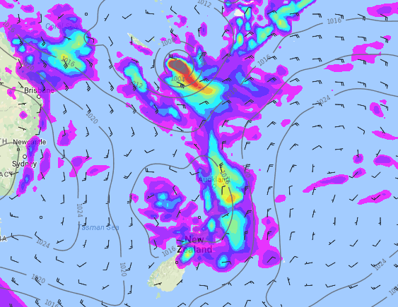 – Weds night/Thurs morning rain crosses New Zealand as Donna tracks south. It’s still far too early to know if severe weather will impact New Zealand in the form of heavy rain, but latest modelling continues to show that Donna will be a close call but may remain safely out to the east. / Weathermap
– WeatherWatch.co.nz
Latest Video

NZ: 8 Day outlook as gales & rain ease, high pressure builds
Damaging wind gusts and heavy rain will continue to affect some parts of the North Island and brushing Marlborough today…
Related Articles
NZ: 8 Day outlook as gales & rain ease, high pressure builds
Damaging wind gusts and heavy rain will continue to affect some parts of the North Island and brushing Marlborough today…

Pockets of hit & miss heavy rain, snow moves northwards
Low pressure continues to slowly move across the upper North Island and for some that will bring the sun out,…

Slow go for northern low & southern cold
For the next few days low pressure will crawl over the upper North Island, driving in rain as far south…

