11,000km high pressure belt to be replaced by deep Southern Ocean low in 7 days time (+2 Maps)
22/05/2019 3:57am

> From the WeatherWatch archives
WeatherWatch.co.nz has today revised the width of the high pressure belt influencing NZ’s weather, from 9000km to 11,000km from west to east.
While this is truly enormous the central air pressure (how we measure the strength of a high) is nothing extreme, around 1028hPa. The high also isn’t perfectly over New Zealand, instead tracking more north which means western areas are getting plenty of cloudy spells and the odd shower. This changes on Friday and Saturday as easterlies develop, then winds from the northerly quarter kick in for the weekend, due to the centre of the high crossing NZ and moving out to our east.
Early next week this high will still hold on to the North Island but a deepening very large area of low pressure will be affecting the South Island.
Next week is a complicated set up – there is the chance of gales, snow, thunderstorms and heavy rain – but also some large areas of sunny, warmer than average weather too.
High pressure just north of NZ may put a limit or ‘cap’ on how far the heaviest rain will go – and considering the North Island needs the rain the most this set up is still not a ‘perfect’ one for soaking rains for everyone, but it’s another shot at getting some moisture.
Also, the centre of this low looks a long way south of the country – that’s the energy maker for the rainbands so the further away the centre of the low is the less likely rainfall totals will amount to much in the north.
We’ll be fine tuning this forecast more so this weekend and early next week and we’ll include expected rainfall totals too.
TODAY / WEDNESDAY
NEXT WEDNESDAY (7 days from now)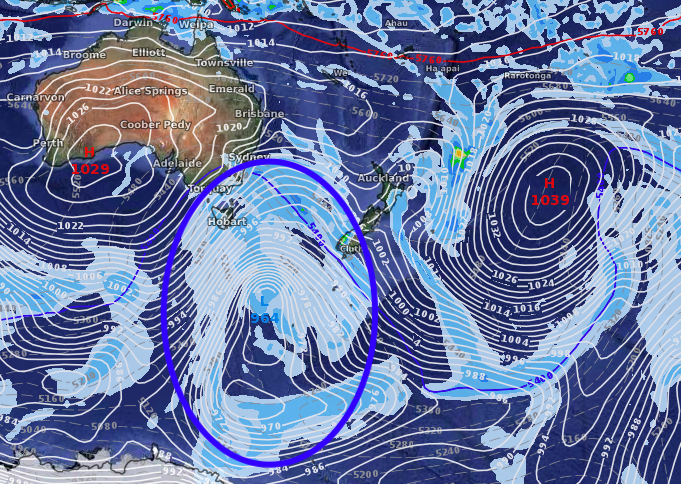
– WeatherWatch.co.nz
Latest Video

Wintry burst of weather: Snow, squally showers then sunshine & frosts
A polar change (another one!) arrives on Friday for the South Island and goes nationwide on Saturday, leaving NZ under…
Related Articles
Wintry burst of weather: Snow, squally showers then sunshine & frosts
A polar change (another one!) arrives on Friday for the South Island and goes nationwide on Saturday, leaving NZ under…

Antarctic southerly for parts of NZ Fri & Sat
For the first time this year a southerly from off Antarctica is heading towards the South Island, followed by more…

Meteors – Your Eyewitness Reports!
WeatherWatch.co.nz receives meteor reports from all over New Zealand and the globe, 24/7/365. **CASUAL COMMENTS**If you’ve seen something in the…

