Winter arrives in NZ and like clockwork winter weather turns up! (+5 Maps)
1/06/2019 1:03am

> From the WeatherWatch archives
Updated 1pm Saturday — It’s the first day of Winter 2019 on the meteorological calendar and Mother Nature knows it, dropping temperatures, bringing hail, thunder, heavy snow and downpours.
A low is crossing New Zealand and while the westerly flow over the North Island isn’t too bad for some regions (bringing mild and mostly sunny conditions to more sheltered areas, like the east) the peak of the coldest polar air won’t be until tonight or even Sunday for some.
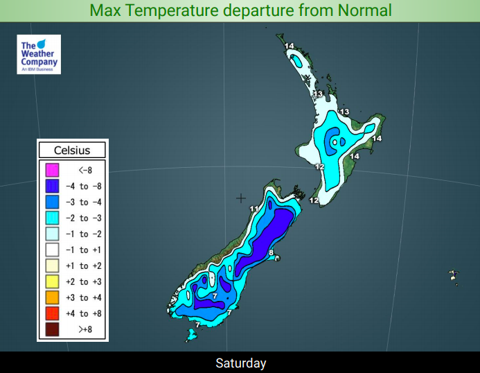
The calmer sunny spells may still be mild for some places today (see the Saturday Departure from Normal Temperature map below) but for those exposed to the wind or rain it will be a much colder day.
Hail showers are isolated but could affect main centres across both islands.
Tonight is colder than average in every single corner of New Zealand – Sunday night is colder still as winds ease and high pressure builds briefly. But conditions do warm up on Monday slightly ahead of another storm mid next week.


– WeatherWatch.co.nz
Latest Video

NZ: 8 Day outlook as gales & rain ease, high pressure builds
Damaging wind gusts and heavy rain will continue to affect some parts of the North Island and brushing Marlborough today…
Related Articles
NZ: 8 Day outlook as gales & rain ease, high pressure builds
Damaging wind gusts and heavy rain will continue to affect some parts of the North Island and brushing Marlborough today…

Pockets of hit & miss heavy rain, snow moves northwards
Low pressure continues to slowly move across the upper North Island and for some that will bring the sun out,…

Slow go for northern low & southern cold
For the next few days low pressure will crawl over the upper North Island, driving in rain as far south…

