Windy wild Wednesday for many regions (+2 Wind Maps)
20/10/2019 10:22pm

> From the WeatherWatch archives
Wednesday is not the flashest days this week. About 70% of NZ will be colder than average while gales will impact the North Island and upper South Island.
It’s all part of a rough spring set up this week which will see wintry weather spreading nationwide for a time, along with a surge of wind and rain – plus snow on the mountains. And in spring style it’s warmer, sunnier, by Saturday.
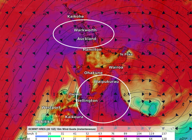
Wednesday appears to be the stormiest day with Auckland and Wellington both exposed to gales over 100km/h (maybe over 130km/h in some exposed hilly areas) and other parts of the North Island. This is getting into powercut potential and damage to trees and small buildings is possible too. There may be some smaller flights delayed too.
Peak winds appear to be from Tuesday evening to Wednesday evening with Wednesday itself very windy around the North Island.
To make sense of this all for where you live please use our new website RuralWeather.co.nz – this has more local data than any other weather website in NZ and means fewer surprises for you. This new website has WIND trends and data for sustained winds and gusts. We have TEMPERATURE graphs covering WIND CHILL and FROST and we have RAIN data covering hourly intensity – plus cloud cover (great if you’re planning your Labour Weekend away). It also covers every airport in NZ.
 ABOVE: AVERAGE WINDS 9AM WEDNESDAY
BELOW: PEAK WIND GUSTS FOR 9AM WEDNESDAY:
Latest Video

NZ: 8 Day outlook as gales & rain ease, high pressure builds
Damaging wind gusts and heavy rain will continue to affect some parts of the North Island and brushing Marlborough today…
Related Articles
NZ: 8 Day outlook as gales & rain ease, high pressure builds
Damaging wind gusts and heavy rain will continue to affect some parts of the North Island and brushing Marlborough today…

Pockets of hit & miss heavy rain, snow moves northwards
Low pressure continues to slowly move across the upper North Island and for some that will bring the sun out,…

Slow go for northern low & southern cold
For the next few days low pressure will crawl over the upper North Island, driving in rain as far south…

