Windy long weekend for Auckland, Northland, Coromandel Peninsula (+3 Maps)
20/10/2021 9:30pm

> From the WeatherWatch archives
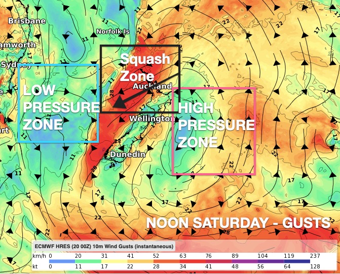
Low pressure in the Tasman Sea and a blocking high to the south and east of NZ will make for windy weather in the upper North Island over the coming days.
With the long weekend approaching and about half of NZ’s population unable to head away, the weather at home this long weekend may be an often windy and cloudy one.
There isn’t a storm moving in – but growing low pressure to the west of NZ will be working with growing high pressure to the east of NZ. These two systems make for a steep gradient of air pressure and squeezes the winds through a narrow space. A bit like how the water in Lake Taupo is calm compared to the Huka falls which has a strong narrow current as the water escapes. In this set up air pressure is squeezed over the upper North Island making for windy easterlies that can gust to gale force and linger for days.
For the most part gale force winds will only be at times, in gusts, in exposed places – but gales (especially in coastal areas) are likely at times on Friday and Saturday especially.
This next burst of east to north east winds kicks in today, peaks Friday/Saturday and eases into Sunday as the low finally moves in, bringing some wet weather.
If you need to make sense of just how windy, for how long for and how gusty it will be at your place – simply visit www.RuralWeather.co.nz and see it all in graph form.


Latest Video

Snow, rain showers & cold polar southerlies set to return
Friday will be a wintry day across NZ as the next cold front arrives, bringing snow to lower levels of…
Related Articles
Snow, rain showers & cold polar southerlies set to return
Friday will be a wintry day across NZ as the next cold front arrives, bringing snow to lower levels of…

Frosts, late week rain & another cold weekend coming
High pressure will cross NZ over the next few days meaning more cold nights/mornings with frosts, but a nor’wester will…

NZ: Cold & windy, then calm & frosty
Downpours, some squally with the chance of thunderstorms and even small tornadoes are possible for parts of NZ over Friday…

