
> From the WeatherWatch archives
Tropical Cyclone continues her slow weakening process as she begins to transition from a tropical cyclone into an extra-tropical cyclone.
Latest data from the government forecaster, MetService, puts her air pressure at 980hPa, indicating she has weakened a little quicker than originally predicted.
In saying that winds are still averaging 100km/h and WeatherWatch.co.nz estimates gusts are still climbing over 150km/h at times near the centre of the storm, which will track right near the Bay of Island and Tutukaka in the immediate hours after midnight tonight.
The storm remains a moderate category 2 cyclone, reports WeatherWatch.co.nz
Despite weakening today, MetService charts indicate the cyclone will weaken very little in the next 12 to 18 hours, and the cyclone still poses a very serious threat to New Zealand the eastern coastline of the upper North Island, from the Far North to East Cape.
So who is likely to be worst hit?

This basic graphic shows the area where Wilma’s winds will be at their strongest. Wilma will weaken as she heads towards Gisborne – and will also accelerate her speed which could create stronger winds on the south eastern side of the low.
Winds within the two red lines are expected to be severe for a time, starting in the Far North later tonight, then eastern Northland in the early hours of Saturday.
On top of the winds MetService have a number of rain warnings out for the upper North Island, which you can find here.
WeatherWatch.co.nz predicts the centre of Wilma will lie east of Great Barrier Island, or north east of Coromandel Peninsula, around 7am Saturday morning then quickly move over East Cape around noon.
The storm’s fast movement means the risk of flooding and wind damage will be limited but please note the seas are incredibly dangerous and will likely pose the most serious threat to people and property.
Swells around the centre of the cyclone are estimated to be between 6 and 8 metres. The average door inside your house is 2 metres high.
Dangerous waves, rips and currents will remains across the east coast of the upper North Island – mainly Northland, Coromandel and Bay of Plenty – until at least the end of Sunday, even if the weather is calm and sunny on Sunday.

The tracking map (above) produced by the Joint Typhoon Warning Centre this morning.
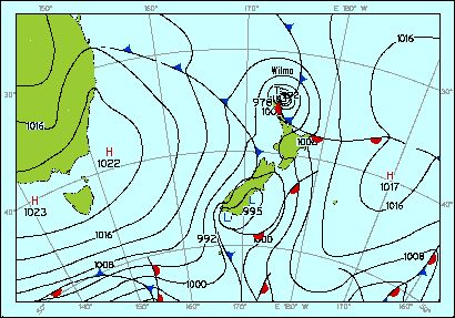
MetService tracking (right) as of 1am Saturday.
WeatherWatch.co.nz predicts most northern areas won’t have very strong winds this afternoon but expects conditions will rapidly go downhill overnight for those in the north east.
It appears Wilma will track too far to the north east of Auckland city to cause too many serious problems wind-wise however winds may still be strong enough to break branches and cut powerlines for a time on Saturday morning – most likely in a window sometime between 3am and 9am. WeatherWatch.co.nz believes a repeat of last weekend’s serious flooding is unlikely, but advises people in coastal areas to be prepared for extra high tides that could cause some coastal flooding.
Strong winds from the southerly quarter will affect all North Islanders tomorrow, with brisk winds in the South Island slowly easing.
Sunday looks settled for most of New Zealand.
– WeatherWatch.co.nz
Comments
Latest Video

Cold weekend, frosts return with high pressure, then a low late next week
The subantarctic airflow spreads over NZ today/tonight and into Saturday, dropping temperatures nationwide. Snow flurries are possible today to lower…
Related Articles

Wintry burst of weather: Snow, squally showers then sunshine & frosts
A polar change (another one!) arrives on Friday for the South Island and goes nationwide on Saturday, leaving NZ under…

Antarctic southerly for parts of NZ Fri & Sat
For the first time this year a southerly from off Antarctica is heading towards the South Island, followed by more…

Snow, rain showers & cold polar southerlies set to return
Friday will be a wintry day across NZ as the next cold front arrives, bringing snow to lower levels of…


Jessica on 28/01/2011 5:49am
Is there anyway that this cyclone could change it’s course and more closer west?
WW Forecast Team on 28/01/2011 6:08am
Hi Jessica – the cyclone may well track closer to New Zealand which is why WeatherWatch.co.nz is trying to inform as many people at her potential power. Keep in mind the strongest winds may still hit land even if the centre doesn’t (of course the centre only has light winds).
– WeatherWatch
Jessica on 28/01/2011 6:23am
Oh exciting. I just love cylones! Can’t remember one since well 14 years ago and even though I was young. Very memorable. Thanks for all these updates. I love this site. You guys are awesome!
Dysan on 28/01/2011 4:05am
Hi! I’m a foreign student from LSI and i’m taking my plane tomorrow at 8.20am to new caledonia from auckland, off course.
I’m worry about the bad weather…
Do you think planes can be cancel tomorrow??
WW Forecast Team on 28/01/2011 6:13am
Hi there – don’t worry, it might be a bit windy but commercial jets are used to flying in conditions like this. Worst case scenario might be a delay of a few hours. Check with your airline in the morning.
Cheers
WeatherWatch
Guest on 28/01/2011 4:00am
How will we fair here in Tauranga/Papamoa – just light rain falling at the moment
Brendan Pratt on 28/01/2011 3:48am
Current data for FrameIT Weather Station
Friday, 28 January 2011 4:48:42 p.m.
Temperature (°C):
Current 19.7
Trend (per hour) -0.8
Average today 22.5
Wind chill 19.7
Heat Index 19.7
Dew Point 18.4
Rel Humidity 92%
Wind (km/h):
Current Gust 13.3 SE
Average Speed 4.2 NE
Rainfall (mm):
Current rate 0.0
Last hour 1.8
Total today 2.1
Total yesterday 0.0
Total this month 198.6
Total this year 198.6
Pressure (hPa):
Current 1012.7
Trend (per hour) -0.7
View more comments