Wednesday’s weather headlines (x3): Wellington gets a good show, More storms today? Humidity set to ease soon
22/03/2022 6:00pm

> From the WeatherWatch archives
Here’s what is making the weather headlines today
MORE THUNDERSTORMS YESTERDAY – A SPECTACULAR SHOW FOR WELLINGTON
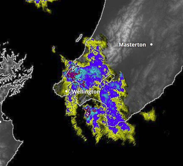
Well we had more thunderstorm activity for some parts of the North Island yesterday, the best show seemed to be Wellington later in the day when a thunderstorm moved in from the north.
Temperatures were very warm at the surface yesterday afternoon with inland areas in the hills behind Wellington warming up into the late twenties, this combined with relatively cool air aloft and a northerly airflow direction brought storms into Wellington late in the day. You can check out photo’s plus video footage from the public by visiting the NZStormchasers public group on Facebook here. Or feel free to visit WeatherWatch’s twitter account here.
Here is a few photo’s of the dramatic clouds as the storm was rolling in to Wellington.

Storms moved through further north earlier in the evening where Mike Wildey took some photographs in Rongotea (near Palmerston North) and said some local sheep had had a good wash at least.

Photo – Mike Wildey 
Photo – Mike Wildey
MORE THUNDERSTORMS TODAY?
Why yes there looks to be more thunderstorms on the way today, mainly for the upper North Island but there could still be one or two elsewhere, perhaps even the low chance of one or two for the inner South Island. Keep up to date with the latest thunderstorm outlook from Metservice here.

HUMIDITY ON ITS WAY SOON
With the northeasterly airflow we have had over the country lately it has been quite humid, good for mushrooms but a little uncomfortable to sleep at night perhaps for some, mainly about the upper North Island. Humidity starts to ease for the South Island on Thursday as a southwesterly front pushes through then easing for the North Island from Friday.
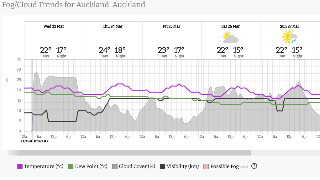
Below I will talk about dew points for Christchurch and then Auckland. Dew points are a measure of humidity, above 15 degrees is starting to get humid feeling and a dew point of around 20 is quite tropical. For more on the dew point temperatures for your location please go to RuralWeather.co.nz – use the search function for your location then click on the “Fog/Cloud” tab.
This graph below is for Christchurch, look at the “Dew Point” line (green line), it starts to drop away from about 4pm in the afternoon on Thursday which is when south to southwesterly winds kick in. Thursday starts early in the day with a dew point around 16 degrees and it ends around 10, on Friday it drops even further to about an 8 degree dew point. In summer when we have northwesterlies in Canterbury dew points can sometimes only be 1 or 2 degrees which means the air is very dry.

The blow graph for Auckland shows dew points today peaking around 18 to 19 degrees so that is bordering on quite tropical feeling, some would say that it very well is! On Friday they will have dropped to about 16 degrees then on Saturday even further to 13 degrees.
Latest Video

More heavy rain, snow – but large dry areas, especially as we go into the long weekend
Heavy rain will continue for parts of Canterbury and Marlborough over the next day or two and it will gradually…
Related Articles
More heavy rain, snow – but large dry areas, especially as we go into the long weekend
Heavy rain will continue for parts of Canterbury and Marlborough over the next day or two and it will gradually…

Large low brings rain, downpours & some snow – gets colder as the week progresses
Low pressure will cross the upper North Island in the days ahead and that set-up actually pushes more heavy rain…

WeatherWatch App launches real-time local lightning tracker!
A bolt out of the blue! WeatherWatch has launched a live, real-time lightning tracker, enabling Kiwis to gain access to data provided by the…

