Weather headlines (x3) for Tuesday: Strong winds far south, Warmest in the east and north, Snow flurries on Wednesday South Island
23/05/2022 7:00pm

> From the WeatherWatch archives
Here’s what is making the weather headlines today.
STRONG WINDS IN THE FAR SOUTH
Coastal Southland, the Catlins and Stewart Island will experience strong westerly winds today. The coastal fringe of the West Coast up through to Taranaki could see gusty southwesterlies today also.
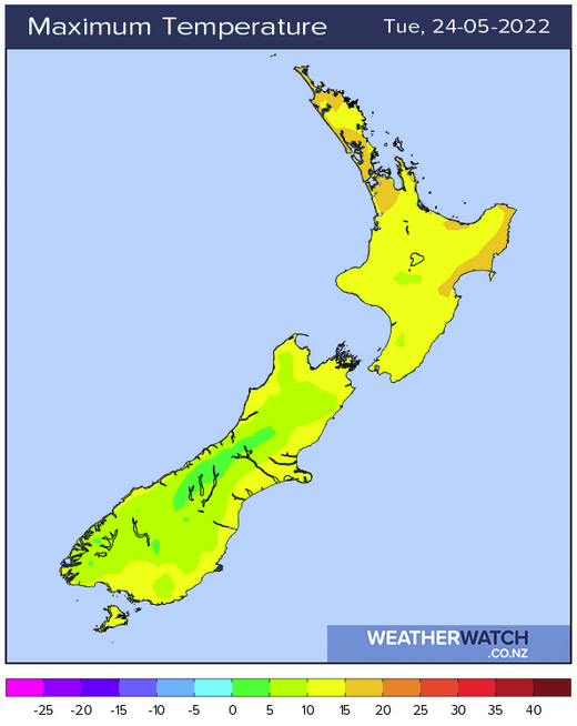
WARMEST IN THE EAST AND UPPER NORTH ISLAND TODAY
Eastern regions Canterbury northwards are sheltered from the southwesterly airflow lying over the country today, it may mean a cold start this morning with frosts but this afternoon temperatures should reach into the mid to late teens. Auckland and Northland being further north should see temperatures in the mid to late teens too although winds could be a little breezier than eastern regions, coming in from the southwest.
Upper North Island 16 -18
Gisborne / Napier 18-19
Blenheim / Christchurch 15-16
A FEW SNOW FLURRIES WEDNESDAY FOR THE SOUTH ISLAND
Some cold air arrives for the southern and eastern South Island on Wednesday as a south to southwesterly airflow pushes through. Expect snow flurries to lower to 400m before clearing overnight about the far south, Canterbury may see snow flurries to 400m later in the day also, falling to 600m overnight for Marlborough.
Any accumulations are not expected to be very high and while snow flurries may fall to the above levels it may not settle, it may require a trip to higher elevations to see snow on the ground.
Latest Video

Slow go for northern low & southern cold
For the next few days low pressure will crawl over the upper North Island, driving in rain as far south…
Related Articles
Slow go for northern low & southern cold
For the next few days low pressure will crawl over the upper North Island, driving in rain as far south…

Slow moving low to track over northern NZ
A low pressure zone will slowly cross the North Island over the coming days, bringing hit and miss pockets of…

NI low pressure, SI polar change
Low pressure will move over the upper North Island this week, bringing hit and miss pockets of heavier rain into…

