Weather headlines (x3) for Thursday: Wet in the west today, Friday gets cold, Strong winds Friday
18/05/2022 7:00pm
> From the WeatherWatch archives
Here’s what is making the weather headlines today.
WET IN THE WEST – THUNDERSTORMS ON ORDER
Western regions certainly get some rain today, out east is drier but there could be a few spots of rain where frontal systems pass over. Southland gets showers today also.
Thunderstorms are looking reasonably likely too, especially for the West Coast then later this afternoon / evening about the southwestern corner of the North Island (Taranaki through to Wellington) as a front moves in.

FRIDAY STARTS TO GET COLD
The airflow starts tending more to the southwest over the South Island during Friday then this spreads to the North Island later in the day. Progressively as winter approaches the weather is not looking to flash but that is to be expected.
Some snow may lower to 400m about the far south of the South Island on Friday, 600m for a time about Canterbury before clearing in the evening. Later in the day the ranges of Wairarapa and the Central Plateau may see snow get down to about 700m.


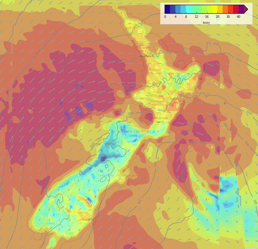
WINDS QUITE STRONG ON FRIDAY
Winds from the northwest today will be strong in spots like the inner South Island east of the Main Divide, also through Cook Strait, but Friday is where it ramps up another notch or 5.
Westerly winds for the North Island will likely be strong for all regions with winds up to gale force at times especially about the western coastline, winds tend to the southwest later in the day with gales in the west.
The South Island has blustery winds too with strong southwesterlies likely for coastal areas in the south, west and east, winds will likely gust to gale now and then especially just offshore.
Wind map – Friday 3pm 
Wind map – Friday 9pm
Latest Video

Rain & showers this weekend, colder change next week
Some places will warm up over the next day or so as a nor’wester out of Australia moves across NZ,…
Related Articles
Rain & showers this weekend, colder change next week
Some places will warm up over the next day or so as a nor’wester out of Australia moves across NZ,…

Temperature changes for some regions ahead of heavy West Coast rain
A nor-wester is about to kick in and it’s coming from out of Australia, boosting temperatures in some regions going…

NZ 7 day forecast: Showers, temp changes and heavy West Coast rain
NZ has a fairly messy forecast over the next 7 days, but the main feature will be heavy rain on…

