Weather headlines (x3) for Thursday: Cold front moves in, Temperatures to drop, Nice this weekend in the east
29/06/2022 7:00pm

> From the WeatherWatch archives
Here’s what is making the weather headlines today.
COLD FRONT MOVES IN
A cold front is still due to move into Southland around midday, reaching Canterbury this evening with a gusty southwest change, strong about the coast. Expect a burst of rain then easing to showers in behind the front. Some snow lowering to 400m in the south by this evening then 500m overnight for Canterbury.
Just before dawn on Friday showers clear in the east north of Otago Peninsula.
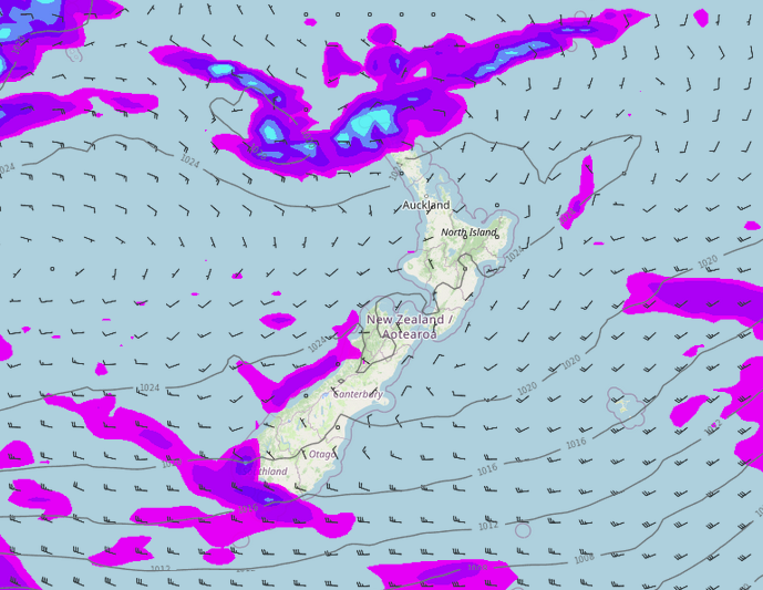
The cold front pushes over the North Island on Friday morning but it will have weakened, it will bring a period of showers to most then drying out from afternoon. Any snow will stick above about 700 to 800m for the Central Plateau and eastern ranges.
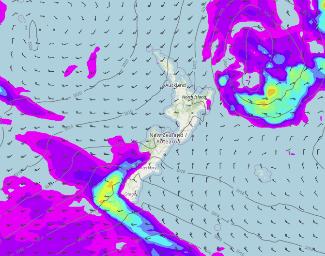
MSLP / Rain map – Thursday Midday 
MSLP / Rain map – Friday 9:00am
TEMPERATURES WILL DROP
Naturally with the cold front mentioned above temperatures will likely drop in the south but further north it’s not all that bad today. Nelson, Marlborough and the Bay Of Plenty will likely be the places to be with temperatures in the mid teens, winds are looking light. Expect sunny weather also although Bay Of Plenty has some cloud this morning but that will clear.

SUNNY, SETTLED AND FROSTY FOR THE EASTERN SOUTH ISLAND THIS WEEKEND
A west to southwesterly airflow lies over the country this weekend, we can expect a few showers for western regions although the western North Island will have long periods of dry. We can also expect a few showers for Southland.
The eastern South Island has a great weekend though with sunny weather on the cards and light winds. The eastern North Island doesn’t do all that badly either but there may be some cloud about now and then.
Saturday 3pm 
Sunday 3pm
Latest Video

Cold weekend, frosts return with high pressure, then a low late next week
The subantarctic airflow spreads over NZ today/tonight and into Saturday, dropping temperatures nationwide. Snow flurries are possible today to lower…
Related Articles
Cold weekend, frosts return with high pressure, then a low late next week
The subantarctic airflow spreads over NZ today/tonight and into Saturday, dropping temperatures nationwide. Snow flurries are possible today to lower…

Wintry burst of weather: Snow, squally showers then sunshine & frosts
A polar change (another one!) arrives on Friday for the South Island and goes nationwide on Saturday, leaving NZ under…

Antarctic southerly for parts of NZ Fri & Sat
For the first time this year a southerly from off Antarctica is heading towards the South Island, followed by more…

