Weather headlines (x3) for Monday: Very heavy rain West Coast, Gale northerlies, Snow overnight to 600m far south
17/07/2022 7:00pm

> From the WeatherWatch archives
Here’s what is making the weather headlines today.
VERY HEAVY RAIN IN THE WEST TODAY
A strong northerly airflow drives in very heavy rain for the West Coast of the South Island today, this is especially so south of about Greymouth. The heaviest falls will naturally be in the ranges. Expect a chance of thunderstorms and hail at times also.
For more details on today’s heavy rain please visit this page here. For today’s thunderstorm risk visit this page here.

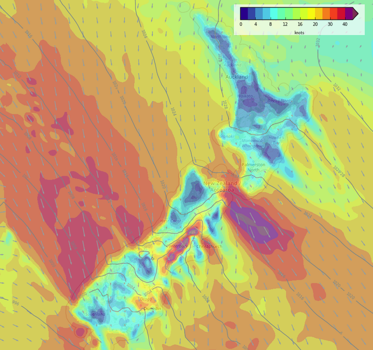
GALE NORTHERLIES TODAY
Along with the heavy rain comes very strong northerly quarter winds today. Winds will be strongest for coastal parts of the West Coast, through Cook Strait and in the east north of Otago Peninsula. Canterbury especially could see very strong northerlies with gales likely.
Once again, for more information on warnings out today regarding the wind please check out this page from Metservice here.
COLD AIR MOVES ONTO THE FAR SOUTH OVERNIGHT
Southerly winds start to push onto Southland and Otago from later this evening, along with the southerlies comes a drop in temperatures.
Snow starts to develop overnight for Southland down to 600m. On Tuesday snow may lower as far as 300m for Southland and down to about 600m in the ranges up to about Banks Peninusla.

MSLP / Rain map – Monday Midnight 
MSLP / Rain map – Tuesday 3:00pm
Latest Video

Frosts, late week rain & another cold weekend coming
High pressure will cross NZ over the next few days meaning more cold nights/mornings with frosts, but a nor’wester will…
Related Articles
Frosts, late week rain & another cold weekend coming
High pressure will cross NZ over the next few days meaning more cold nights/mornings with frosts, but a nor’wester will…

NZ: Cold & windy, then calm & frosty
Downpours, some squally with the chance of thunderstorms and even small tornadoes are possible for parts of NZ over Friday…

WeatherWatch App launches real-time local lightning tracker
A bolt out of the blue! WeatherWatch has launched a live, real-time lightning tracker, enabling Kiwis to gain access to data provided by the…

