Weather headlines (x3) for Monday: Front for the far south, Eastern North Island place to be, Northern low mid week
26/06/2022 7:00pm

> From the WeatherWatch archives
Here’s what is making the weather headlines today.
FRONT MOVES ONTO THE FAR SOUTH, SOME SNOW TOO
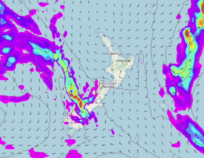
A front moves onto the lower South Island this morning then gradually moves northwards to lie over the central South Island around midnight. Rain moves in with the front, pushing up the West Coast at first then also up into Canterbury this evening.
Some cold air moves in with this front too. While air does get cold for Southland, precipitation clears away as air starts to get overly frigid. A few snow flurries eventually develop to 500m for Southland then thin out and clear away. Otago gets snow to 500m also at night but accumulations should be a little more, snow overnight to 500m for South Canterbury, 700m overnight for North Canterbury.
NICE WEATHER – EASTERN NORTH ISLAND TODAY
A ridge of high pressure brings settled weather to the North Island today, the east coast is particular gets sunny skies with light winds and warm temperatures reaching up to 17 degrees. Anywhere in the east from Bay Of Plenty up through to eastern Northland may see temperatures reach 17 degrees also although there could be a few clouds about now and then.

NORTHERN LOW WEDNESDAY / THURSDAY
A low is still set to brush northeastern parts of the North Island around Wednesday / Thursday this week. South to southwesterly winds later on Wednesday and into Thursday strengthen for the upper North Island, winds may be strong to gale force about some coastal parts then easing from Thursday afternoon.
As the low slips away to the southeast heavy rain is possible too but only for a brief time. Eastern Northland first then Great Barrier Island / Coromandel, finally East Cape and Gisborne. Rain for East Cape / Gisborne looks to be the longest lasting so any potential issues that arise regarding rain will more than likely be there.

Rain map – Wednesday 9:00pm Wind map – Thursday 3:00am
Latest Video

Large low brings rain, downpours & some snow – gets colder as the week progresses
Low pressure will cross the upper North Island in the days ahead and that set-up actually pushes more heavy rain…
Related Articles
Large low brings rain, downpours & some snow – gets colder as the week progresses
Low pressure will cross the upper North Island in the days ahead and that set-up actually pushes more heavy rain…

WeatherWatch App launches real-time local lightning tracker!
A bolt out of the blue! WeatherWatch has launched a live, real-time lightning tracker, enabling Kiwis to gain access to data provided by the…

Polar airflow + northern low = pockets of heavy rain & snow
A colder change is coming – and so too is a large low which will develop and grow over northern…

