Weather Headlines for Tuesday (x3): Humidity, more heavy rain then eyes on the end of the week
7/02/2022 6:00pm
> From the WeatherWatch archives
HIGH HUMIDITY / MUGGINESS CONTINUES FOR THE UPPER NORTH ISLAND
An northeasterly feed is bringing in very humid air for the upper North Island today from the tropics and this continues for the rest of the week ahead. Sunday or Monday next week may finally see some relief but perhaps not before some turbulent weather moves through.
Graph below showing a high dew point temperature for Auckland (green line), a dew point around 20 degrees feels quite tropical. It finally starts to drop away on around Sunday or Monday. You can see this graph by clicking here.
More information on dew points by clicking here.

A FOGGY START IN THE SOUTH
With clearer skies last night and reasonable moisture in the air, low cloud or fog is possible about some inland areas of the lower South Island this morning, after some day time heating gets going it should clear fairly promptly. Fog is possible again in the same areas overnight tonight.
Graph below showing the fog risk for Gore, Southland this morning and again tomorrow morning. Note; the risk occurs where the “Dew Point” and “Temperature” lines meet. You can see this graph by clicking here.

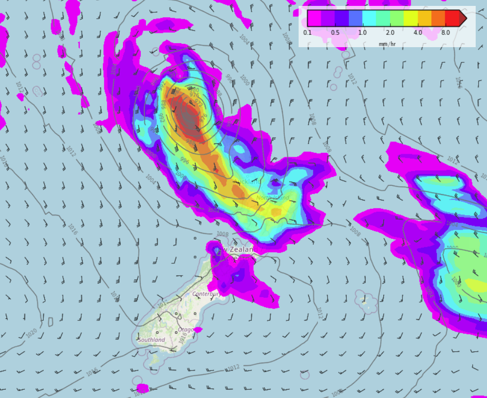
MORE HEAVY RAIN ON THE WAY FOR THE WEST COAST, ALSO EYES ON THE END OF THE WEEK
Heavy rain moves onto the West Coast of the South Island from Wednesday afternoon, easing Thursday.
Our attention then turns to this coming weekend when some turbulent weather may affect the North Island, nothing is locked in at this stage but eyes should cast ahead to either Saturday or Sunday when an ex tropical cyclone may affect the North Island. As Phil Duncan has mentioned a few times this summer, due to New Zealand’s narrow landmass and its orientation in that it runs from northeast to southwest, any systems coming down from the north can miss us if they move a little further to the east or west than models indicate. But still, it is something we should be keeping an eye on. Keep up to date with the latest rain forecast maps by clicking here.
Latest Video

NZ 7 day forecast: Showers, temp changes and heavy West Coast rain
NZ has a fairly messy forecast over the next 7 days, but the main feature will be heavy rain on…
Related Articles
NZ 7 day forecast: Showers, temp changes and heavy West Coast rain
NZ has a fairly messy forecast over the next 7 days, but the main feature will be heavy rain on…

Cold fronts continue, wind & rain for some Fri/Sat
Wet weather is moving over the North Island today, while the South Island has drier skies – ahead of another…

Cold fronts vs high pressure
A cold front is moving up NZ today and into Tuesday, but will fall apart as it heads north and…

