Weather Headlines for Thursday (x3): The path of the heavy rain, Facial Eczema? Cooler southerlies in the south
2/02/2022 6:00pm

> From the WeatherWatch archives
Heavy rain South Island moves to the North Island Sunday
It’s all about the rain, the South Island in particular the West Coast sees heavy rain today and Friday, inland Canterbury may actually see some heavy rain into the second half of Friday before starting to ease overnight. Heavy rain moves to the upper South Island (Tasman, Nelson and perhaps Marlborough) on Saturday then heavy rain potential shifts to the North Island on Sunday and continues there early next week. There is still room for change here so not everything is set in stone just yet. More at this link here.
High humidity and rain potential may bring facial eczema
With the dry weather we have had for the North Island lately and now high humidity plus the potential for high amounts of rain coming up this leads to the potential for facial eczema in livestock. Something to take note of.
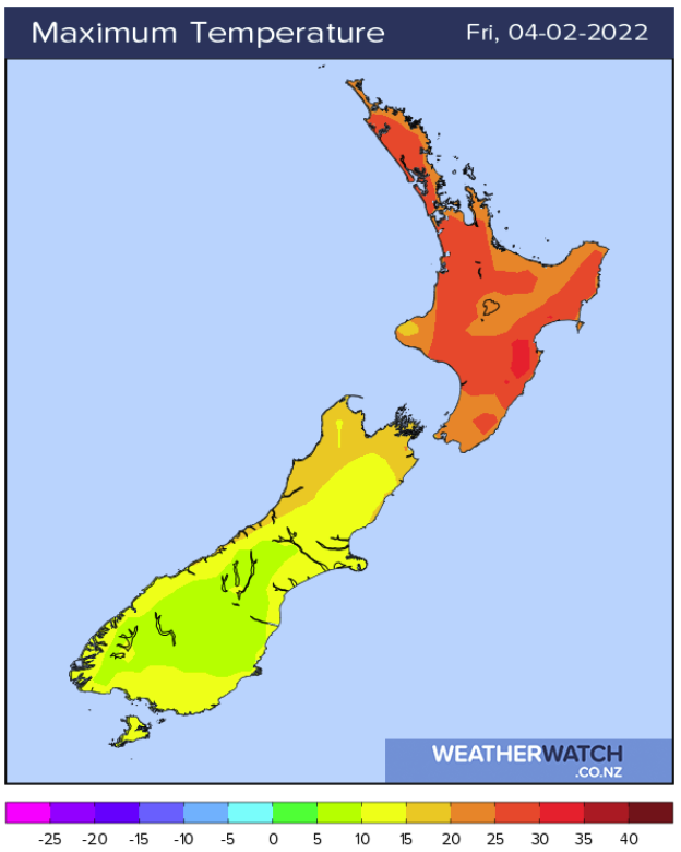
Relief is coming in the south
Relief from hot temperatures is starting to move in today for the South Island with southerly winds. The lower South Island will notice this today, the upper South Island tomorrow. The North Island remains very hot then starts to see some relief later into Sunday and Monday.
Latest Video

Cold weekend, frosts return with high pressure, then a low late next week
The subantarctic airflow spreads over NZ today/tonight and into Saturday, dropping temperatures nationwide. Snow flurries are possible today to lower…
Related Articles
Cold weekend, frosts return with high pressure, then a low late next week
The subantarctic airflow spreads over NZ today/tonight and into Saturday, dropping temperatures nationwide. Snow flurries are possible today to lower…

Wintry burst of weather: Snow, squally showers then sunshine & frosts
A polar change (another one!) arrives on Friday for the South Island and goes nationwide on Saturday, leaving NZ under…

Antarctic southerly for parts of NZ Fri & Sat
For the first time this year a southerly from off Antarctica is heading towards the South Island, followed by more…

