Weather Headlines for Saturday – A risk of inland fog, warming up then rain in the west
28/01/2022 6:00pm

> From the WeatherWatch archives
Big high and mainly settled, fog possible?
As we have a big high parking over us today and hanging around till early next week this brings the possibility of fog for some inland areas morning and night, there likely won’t be any major issues here but something to keep an eye on if it pertains to you. Saturday through to Tuesday. Go to ruralweather.co.nz, type in your centre then click on the “Fog/Cloud” tab, you’ll be able to see if fog is possible for you coming up. The link below for Reefton shows fog possibilities when you click on the “Fog/Cloud” tab for e.g.
https://www.ruralweather.co.nz/forecasts/Reefton,%20West%20Coast

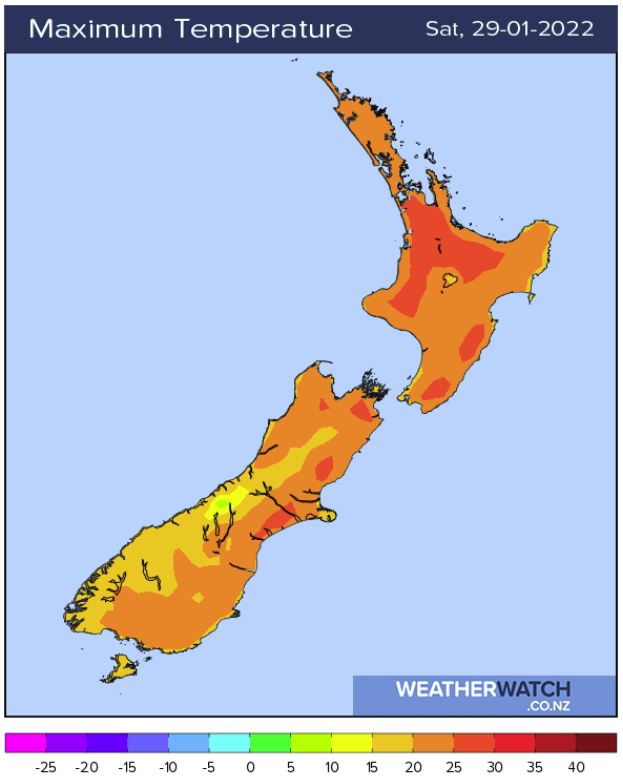
High’s reaching into the thirties inland through till Tuesday
Temperatures about some inland areas especially the inner South Island and perhaps inland parts of the North Island at times will reach into the early thirties on Saturday through till Tuesday next week. Wednesday and Thursday conditions become very warm for eastern regions of both Islands.
Rain still on track for early February
A low descending into the Tasman Sea on the 1st February brings down some rain which starts affecting the far north, February 2nd through till the 4th at least expect some rain, mainly in the west and especially the western South Island. Eastern regions may need to wait a few days longer if long range maps stay consistent. The precipitation (% of normal) map below shows this rain, this map covers Thursday 27th January through to Friday 5th February 2022.
Long range rain maps can be found be clicking here.

Latest Video

Slow go for northern low & southern cold
For the next few days low pressure will crawl over the upper North Island, driving in rain as far south…
Related Articles
Slow go for northern low & southern cold
For the next few days low pressure will crawl over the upper North Island, driving in rain as far south…

Slow moving low to track over northern NZ
A low pressure zone will slowly cross the North Island over the coming days, bringing hit and miss pockets of…

NI low pressure, SI polar change
Low pressure will move over the upper North Island this week, bringing hit and miss pockets of heavier rain into…

