Weather focuses more on South Island as high pressure dominates the north (+5 Maps)
27/02/2020 7:35pm

> From the WeatherWatch archives
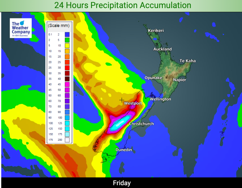
A deluge moving up the West Coast Friday will fall apart by the time it moves into the western North Island on Saturday, says WeatherWatch.co.nz.
Friday’s deluge is significant with 200mm possibly falling within just 24 hours from about Hokitika southwards to the glaciers, up in the mountains. This could cause flooding, slips and some road closures.
But the front isn’t going to be dumping much wet weather over the dry North Island. The front moves into Taranaki and the south west corner of the North Island and will bring some rain and showers on Saturday but will be fast falling apart. The further north the front goes the more high pressure it runs into and the faster it dies.
It looks as though any wet weather will make it to about Taranaki or Waitomo. Any showers north of that will likely be so light and isolated they may not even be worth mentioning.
Meanwhile Friday is hotter than average in most places but the cold front in the South Island does have cooler air behind it – so Saturday night and day will be a little cooler in some regions, like Canterbury which could be nearly 10 degrees cooler on Saturday compared to today, Friday.


– WeatherWatch.co.nz
Comments
Latest Video

Antarctic southerly for parts of NZ Fri & Sat
For the first time this year a southerly from off Antarctica is heading towards the South Island, followed by more…
Related Articles
Antarctic southerly for parts of NZ Fri & Sat
For the first time this year a southerly from off Antarctica is heading towards the South Island, followed by more…

Meteors – Your Eyewitness Reports!
WeatherWatch.co.nz receives meteor reports from all over New Zealand and the globe, 24/7/365. **CASUAL COMMENTS**If you’ve seen something in the…

Snow, rain showers & cold polar southerlies set to return
Friday will be a wintry day across NZ as the next cold front arrives, bringing snow to lower levels of…


Obai on 27/02/2020 10:55pm
From where can I see the average temperatures for Auckland in this time of year, or any time ?
WW Forecast Team on 28/02/2020 12:02am
Hi there
You can use this link: https://www.metservice.com/towns-cities/locations/auckland/past-weather
Then click on “Historical Data”.
Or use this link: https://en.wikipedia.org/wiki/Auckland
And scroll down to the “Climate” section.
Hope that helps!
Cheers
Aaron