Warm, humid, cloudy week ahead – this is what La Nina feels like in NZ (+13 Maps)
25/10/2021 10:59pm

> From the WeatherWatch archives
Increased humidity, warmth and cloud cover this week is a taster of what La Nina weather conditions in NZ are like. The developing La Nina – which sees warmer than usual sea surface temperatures north of NZ – is expected to influence NZ’s weather to some degree in the coming months. The most obvious sign in NZ is increased humidity, cloud and northerlies.
This set up means the south of NZ is well above normal temperature-wise this week. A large portion of the inland South Island will be over 8 degrees above normal (as far as maximum temperatures are concerned) for the next few days ahead. Places like Gore have highs in the early 20s … with a cool down arriving on Sunday (and the cool down simply puts temperatures back to where they should be for this time of year).
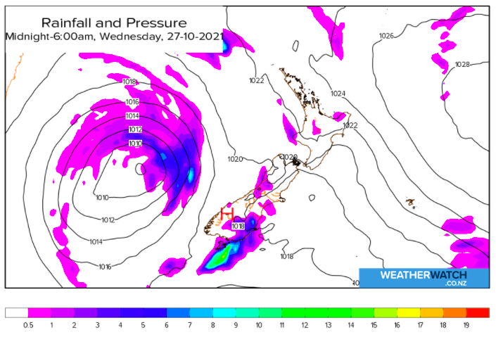
Despite an increase in cloud and wet weather, rainfall totals may not be overly high. Most places lean drier than average, or for some in the western North Island about average. So if your local forecast has plenty of rain icons – check out the rainfall totals too, and you’ll notice for many places they aren’t overly high.
It will be a mild week nationwide with heaviest rain through the central North Island.


Red = Drier than average, White = Normal rainfall for late October, Blue = Wetter than usual


Latest Video

Rain & showers this weekend, colder change next week
Some places will warm up over the next day or so as a nor’wester out of Australia moves across NZ,…
Related Articles
Rain & showers this weekend, colder change next week
Some places will warm up over the next day or so as a nor’wester out of Australia moves across NZ,…

Temperature changes for some regions ahead of heavy West Coast rain
A nor-wester is about to kick in and it’s coming from out of Australia, boosting temperatures in some regions going…

NZ 7 day forecast: Showers, temp changes and heavy West Coast rain
NZ has a fairly messy forecast over the next 7 days, but the main feature will be heavy rain on…

