Updated rain maps (x7) for New Zealand and Australia as spring rainmakers move through
5/10/2021 7:49pm

> From the WeatherWatch archives
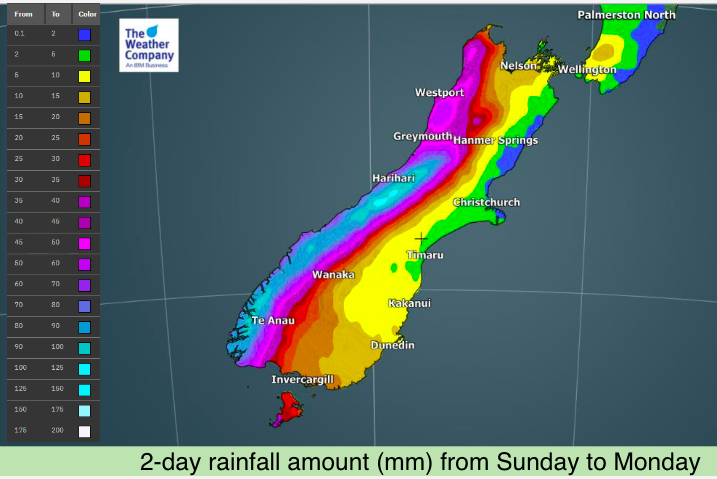
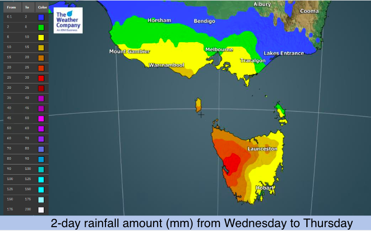
There is no shortage of wet weather moving across both NZ and Australia over the next 7 days. From Australia’s desert to normally dry parts of the upper South Island in NZ, heavy rain is moving through in waves over the coming week thanks to a number of fronts and lows tracking by.
This is peak spring chaos – although there is some order to it, with the bulk of the weather moving from west to east. In saying that, next week in NZ there may be a new low that deepens off the eastern side of the country bringing in a wet southerly for eastern regions in both main islands, up to Gisborne.
In the maps below we break down the rain surges over the coming days across New Zealand and Australia. Parts of Aussie – including normally very dry Alice Springs – have more heavy rain and thunderstorms. Alice Springs has had a number of wet weather events this year (not the usual), some of which make it to NZ.
As always, drill down much deeper using www.RuralWeather.co.nz or our free app (also, Australians, despite our app being NZ based it does also include your local forecasts right across Australia!).


Latest Video

Wintry weather coming: Snow, rain, wind & sunshine
A cold front is moving into NZ from Friday to Sunday with low pressure developing west of NZ and then…
Related Articles

Polar airflow + northern low = pockets of heavy rain & snow
A colder change is coming – and so too is a large low which will develop and grow over northern…
Wintry weather coming: Snow, rain, wind & sunshine
A cold front is moving into NZ from Friday to Sunday with low pressure developing west of NZ and then…

ClimateWatch: JULY outlook & what El Niño means for NZ
El Niño is officially here and still getting stronger in the months ahead, but it’s harder to notice its effects…

