Unsettled Easter: Some high pressure to limit northern severity but still a serious low to monitor
5/04/2020 8:32pm

> From the WeatherWatch archives
A deep low in the Southern Ocean (with similar air pressure to Cyclone Harold right now) will be tracking past New Zealand this Easter Weekend and for some regions it will be much windy, cooler and wetter than previous weeks.
As we said last Friday we’d need a few days into early this week to fine tune the set up. Here’s what has changed in the computer modelling since we updated on Friday:
Some Backing Off…
- More high pressure in the Tasman Sea will limit how far north severe weather goes (positive for some, a negative for those in drought)
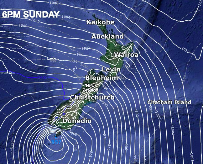
- The centre of the low itself may not be quite as deep (but still similar to the severe cyclone near Vanuatu which is why we’re tracking this so closely). ECMWF data says 950hPa range near the southern coastline of the South Island.
- The North Island looks less exposed to severe weather – although gales possible
- Coldest air less likely to reach northern NZ
- Coldest air less likely to linger over all of NZ for as long (probably about 36 hours around Easter Sunday and Monday.
Rough Weather: Timing & Where…
- Winds pick up in the South Island over Saturday and Sunday with gales developing into the North Island across Sunday
- Sunday will be windy nationwide and Monday too
- Air pressure in the southern most parts of the South Island may drop into the 960hPa range (or 970s)
- Easter Monday looks windiest for the North Island
- Coldest weather peaks Monday night/Tuesday
Best Weather…
As we said in our updates last week, the angle of the winds for this event plus New Zealand’s mountains and ranges means some regions will have plenty of sun, added warmth and may not always been windy.
Good Friday may have some pleasant weather around the country, then as the winds crank up over Saturday, Sunday and Monday some eastern areas may be quite sunny.
Northern NZ looks unlikely to see much of a temperature drop from this event.
Sunniest and driest weather will be in the east and north east of both islands.
Worst Weather…
We see the weather going downhill over Wednesday and Thursday, then looks to be a pause on Good Friday thanks to some Tasman Sea high pressure, before the main event starts to build Saturday then peaks across Sunday and Monday as a burst of wind, rain, and South Island snow in the mountains and ranges.
Windiest weather will be nationwide by Sunday and Monday but the usual areas will be most exposed, ie: Cook Strait, the Southern Alps, the lower South Island and possibly Auckland (due to the sou’west wind tunnel).
Coldest weather will be in the lower South Island with a brief taste on Thursday then the main cold air surges up this weekend and peaks over Sunday and Monday with wintry conditions for a time in some places.
Snow is not forecast by WeatherWatch.co.nz in any main centres.
Wettest weather will be on the West Coast.
AIR PRESSURE:
While the air pressure compared to Severe Cyclone Harold near Vanuatu today may be similar to the low pressure forming in the Southern Ocean over Eastern Weekend there is an enormous difference. “Tropical cyclones see all that low energy explicitly at the very centre of the storm. But cold Southern Ocean storms can see that low energy spread over a distance of thousands of kilometres. The spreading of all that energy also removes some of the peak wind speeds, so there are positives with more people being affected. A tropical cyclone covers less distance but has much more devastating weather near the centre.
The timing and shape of this event may still change a little further, we will be locking more details in by Wednesday.


WeatherWatch.co.nz
Latest Video

Matariki, the long weekend + the outlook for next week
Wet weather and cloud continues along the eastern side of the country with the heaviest rain now moving into northern…
Related Articles
Matariki, the long weekend + the outlook for next week
Wet weather and cloud continues along the eastern side of the country with the heaviest rain now moving into northern…

More eastern rain, but a drier long weekend coming
Rain continues today along the eastern South Island and lower North Island, coming in from the east with heavy falls….

More heavy rain, snow – but large dry areas, especially as we go into the long weekend
Heavy rain will continue for parts of Canterbury and Marlborough over the next day or two and it will gradually…

