Typhoon Hagibis now departing Japan – Latest forecast & tracking (+4 Maps)
12/10/2019 11:27pm

> From the WeatherWatch archives
Typhoon Hagibis made landfall Saturday night in Japan and is now already exiting the nation, but more severe weather is likely today before finally clearing tonight.
CURRENTLY:
-
Central Pressure is 975 hPa
-
Max sustained wind is 60 kt (110 kmh) with gust 85 kt (160 kmh)
-
STS Hagibis travels north-northeastward quickly now at 31 kt (57 kmh). This is a real positive as it means the storm will move away from Japan quickly today.
IMPACTS:
-
Rain: Torrential rain and thunderstorms is expected over Northern Japan until Sunday noon (JST). Also, Rain totals in 24 hours of 100-150 mm are likely with localized spots receiving up to 200 mm over there on Sunday.
-
Wind: Up to 100km/h widely expected over Pacific Ocean side of Hokkaido and Tohoku on Sunday.
-
Wave: 10 m or more of Significant Wave Height (SWH) is expected over the Pacific side of Tohoku on Sunday. In Tohoku and Hokkaido, the time when the waves are highest overlaps the time of high tide on Sunday afternoon.
-
From the above, Planed suspension of transportations are likely over Kanto, Metropolitan and Tohoku until Sunday morning at least.
-
Main threat are landslides, flooding, swollen rivers, lightning strikes, violent winds, collapse of buildings, salt damage and high waves over Northern Japan.
- Power outages due to gusty wind cannot be denied on Tohoku and Hokkaido.
Our thanks to our partners at The Weather Company in Japan for sending us this local update.
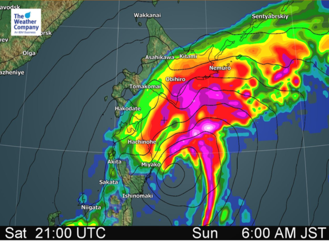
 Location on Sunday morning.


– WeatherWatch.co.nz – An official IBM business partner.
Latest Video

Westerlies continue, sub-tropical for some
West to north-west winds blow through the South Island and lower North Island today bring heavy West Coast rain and…
Related Articles
Westerlies continue, sub-tropical for some
West to north-west winds blow through the South Island and lower North Island today bring heavy West Coast rain and…

Westerly change this week, unsettled but large dry areas
Westerlies kick back in again this week which will bring a break to those in the east as far as…

Matariki, the long weekend + the outlook for next week
Wet weather and cloud continues along the eastern side of the country with the heaviest rain now moving into northern…

