Tonga: It doesn’t get much worse than this, Cyclone Gita likely to make direct hit (+6 Maps)
12/02/2018 1:33am

> From the WeatherWatch archives
The latest forecast for Tonga is not something you want to see – a forecast for already Category 4 Severe Cyclone Gita to reach Category 5 status (the highest on the scale) in the Tonga area and likely make a direct hit over the top of Tonga and the capital Nuku’alofa on the main island Tongatapu tonight and early Tuesday.
Over 75,000 people are in the path of a storm already more powerful than anything New Zealand has ever seen with torrential rain and damaging winds forecast to be averaging close to 200km/h and gusting over 230km/h by tonight when it makes landfall there.
Maximum wave heights could be in excess of over 10 metres with storm surge at the centre of the cyclone lifting the sea up even further leading to coastal inundation and sending those waves even further inland. These incredibly dangerous seas could last 24 hours aroud the southern islands of Tonga.
The most severe portion of wind and rain at the centre of the low will last around 12 to 18 hours over Tongatapu.
Powerful cyclones do tend to wobble at times from the forecast tracking. A last minute jog to the south could have significant benefits to Tonga, but a jog to the north could make things worse. These ‘wobbles’ are unpredictable, as we saw with Category 5 Cyclone Winston in 2016 which at the last hour wobbled off the forecast track and ended up making landfall in Fiji instead of remaining just out at sea.
By Tuesday afternoon conditions should be calmer in Tonga weatherwise, although dangerous seas and more normal rain could linger through Wednesday.
Computer modelling agrees that a direct hit to Tonga from the centre of Gita looks highly likely in the main southern island of Tongatapu overnight tonight.
With the island being so small, there is a chance Gita won’t technically make landfall (when the centre crosses land), but even a close brush will be equally as damaging.
WHAT HAPPENS AFTER TONGA?
Beyond Tonga the computer models remain divided. They do agree Gita will remain a powerful Cat 5 or Cat 4 storm for the days ahead and track westwards, but they don’t yet agree when the storm will start to turn south into the Tasman Sea.
Norfolk Island (Australian territory just to the north west of New Zealand), still runs a risk of a direct hit but even New Caledonia (French territory) much further north could be exposed – highlighting the uncertainty about the future precise tracking of this storm and this will affect when we can be more detailed about how New Zealand might be impacted.
WeatherWatch.co.nz says there is increasing confidence New Zealand will be affected by Cyclone Gita but it is still too early to lock in the intensity or timing. Reliable models are showing the storm reaching New Zealand anywhere from this Sunday to next Wednesday with varying intensity. Many of you are seeing the various models in the public domain, some show a direct hit to New Zealand this Sunday while others show the storm almost reaching Australia before curving back towards New Zealand next Wednesday. So this large uncertainty means we should definitely keep the focus on Tonga for the next 24 hours.
The last Category 5 cyclone in the South Pacific to make landfall was Cyclone Winston in 2016 which hit Fiji.
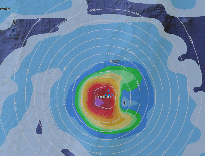
 Tracking today and tomorrow shows a direct hit. Due to the incredible power of major cyclone like this they can “wobble” as they track along that line. A last minute wobble southwards could reduce damage, a wobble northwards from this projected line would likely make things even worse for Tonga. Image by The Weather Company/IBM
 – Tracking from JTWC (US Government)
 – Tracking by the Fiji Met Service
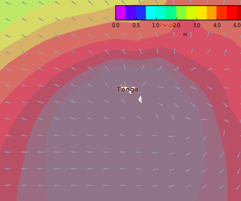 – Swell map for 1am Tuesday shows major swells and waves, over 10 metres which will cause coastal inundation in some areas / MetOcean
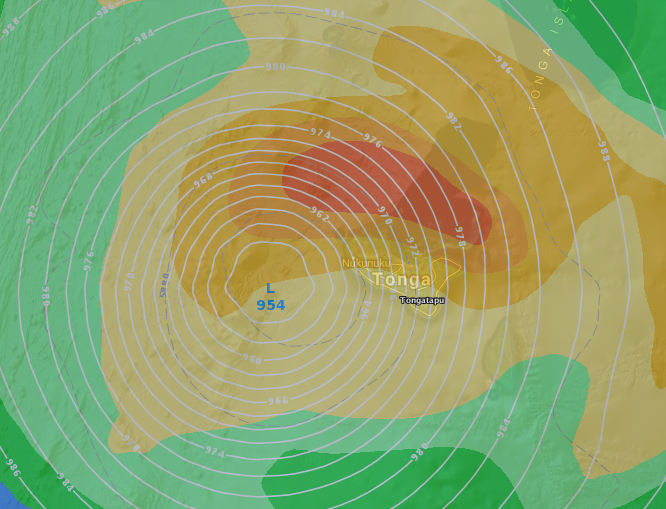
– ECMWF (Europe) computer modelling showing the centre of Gita passing over Tonga late tonight and in the early hours of Tuesday
 – GFS (US Government) agreeing with ECMWF about where the centre of Gita will track overnight tonight in Tonga.
– WeatherWatch.co.nz (an official IBM and Weather Company business partner)
Comments
Latest Video

Frosts, clearer skies coming – severe weather possible this weekend
High pressure lies south of NZ today and that placement encourages a colder south-east wind into the North Island bringing…
Related Articles
Frosts, clearer skies coming – severe weather possible this weekend
High pressure lies south of NZ today and that placement encourages a colder south-east wind into the North Island bringing…

NZ: 8 Day outlook as gales & rain ease, high pressure builds
Damaging wind gusts and heavy rain will continue to affect some parts of the North Island and brushing Marlborough today…

Pockets of hit & miss heavy rain, snow moves northwards
Low pressure continues to slowly move across the upper North Island and for some that will bring the sun out,…


Guest on 11/02/2018 7:55pm
Is there are reason why Tropical Cyclones appear to use scale that is different than southern Atlantic Hurricanes? Is it correct that a Cat 5 TC is really only about a Cat 4 in the Atlantic scale? It’s a really misleading system in my view. A hurricane is a hurricane is it not, regardless where on the earth it forms and all have the same underlying physics? Has a Tropical Cyclone ever reached a “true” Cat 5 strength?
WW Forecast Team on 11/02/2018 8:27pm
Hi there, yes every part of the world uses a different system created for their zone. We agree it’s a bit confusing, it was set up before the internet era and these days we hear much more about Hurricanes and Typhoons and so people get a bit confused. Here’s the list of all the different categories from around the world. This is supported by the World Meteorological Organisation (all the Government forecasters basically).
Cheers
WW