Thursday’s weather update (today is Thursday if you’re on holiday…)
29/12/2021 3:00pm
> From the WeatherWatch archives
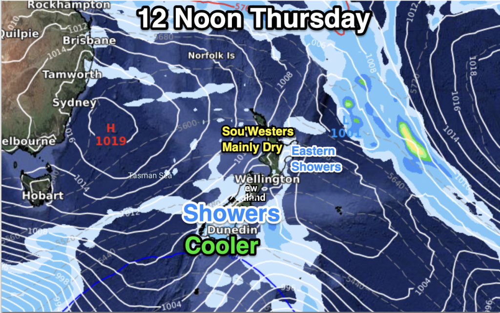
One more surge of colder air is moving up the South Island today, once again knocking back daytime highs below where you’d expect for the end of December.
Some parts of Southland and Otago may again struggle to reach the teens today – but warmth does come back on Friday and in fact by Sunday parts of Southland will be in the low 30s. So have no fear, summer is not yet done for you, but it is a bit up and down at the moment.
Dunedin has cooler weather also, then a warm up in the days ahead – but Dunedin’s being impacted by cooler air in the Southern Ocean area that slides past southern NZ and brushes Dunedin as it swirls around the Otago coastline. Dunedin is cooler today, then milder in the days ahead, but it may again be back to highs in the teens by the middle of next week.
As we go through Thursday these showers along with the cooler air move up Canterbury before fading before reaching the North Island, although a few showers may be sparked along the eastern North Island up to about Gisborne, but without the temp drop.
The rest of the country is looking mostly dry and mild.
Check your hyper-local RuralWeather.co.nz or WeatherWatch.co.nz forecast for more details. We’ll have more info later today on how NYE and NYD are shaping up – plus the start of 2022!
Comments
Latest Video

Cold weekend, frosts return with high pressure, then a low late next week
The subantarctic airflow spreads over NZ today/tonight and into Saturday, dropping temperatures nationwide. Snow flurries are possible today to lower…
Related Articles
Cold weekend, frosts return with high pressure, then a low late next week
The subantarctic airflow spreads over NZ today/tonight and into Saturday, dropping temperatures nationwide. Snow flurries are possible today to lower…

Wintry burst of weather: Snow, squally showers then sunshine & frosts
A polar change (another one!) arrives on Friday for the South Island and goes nationwide on Saturday, leaving NZ under…

Antarctic southerly for parts of NZ Fri & Sat
For the first time this year a southerly from off Antarctica is heading towards the South Island, followed by more…


Peter Thomas Langer on 29/12/2021 11:01pm
look at your rainfall abnomly map that doesnt look like la nina the places that should be wet are dry and the places that should be dry in la nina are wet
WW Forecast Team on 29/12/2021 11:36pm
Hi Peter,
With La Nina it doesn’t mean it rains all the time, it means those areas to the north (Coral Sea especially) are more prone to rainmakers. The weather pattern over NZ isn’t very La Nina though, due to the Southern Ocean high pressure zones which we talked about back in November being a key part to our summer pattern too.
Cheers
WW
Peter Thomas Langer on 30/12/2021 3:25am
wheres your weather outlook for jan…..more droughts for the north island since the highs cant go south to let the tropics in
WW Forecast Team on 30/12/2021 6:36am
We have a ‘watered down’ (excuse the pun) ClimateWatch outlook on Saturday. But the main one from Dec 1 carries on through Jan. Next main update is start of Feb.
– WW