
> From the WeatherWatch archives
It’s more like land of the long grey cloud today as a large low in the Tasman Sea hugs the western South Island and drags down cloud over much of New Zealand.
While in the north the air pressure is higher so rain clouds will be more likely producing drizzly showers today but further south heavy rain again continues to fall on the West Coast and some gets into Southland and Otago – where a more wintry change is also developing.
In fact despite the cloud most of New Zealand will again be mild today with above normal temperatures – except for Southland and Otago which become colder due to a separate airflow coming out of the Southern Ocean. Most other regions have northerly quarter winds or sub-tropical winds.
The low isn’t getting bigger nor is it really moving in, it’s stalled and will slowly unravel in the days ahead. So don’t expect a big sunny change just yet over New Zealand – but neither do we have a big low crossing NZ.
AIR PRESSURE MAP AT 12NOON THURSDAY:
THURSDAY’S 24 HOUR RAINFALL:
THURSDAY’S 24 HOUR RAINFALL: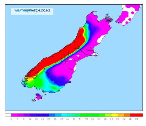
THURSDAY’S 24 HOUR RAINFALL:
THURSDAY PM MAX TEMPERATURES:
THURSDAY PM MAX TEMPERATURES:
 – Himawari Satellite Map
– WeatherWatch.co.nz
Latest Video

Cold weekend, frosts return with high pressure, then a low late next week
The subantarctic airflow spreads over NZ today/tonight and into Saturday, dropping temperatures nationwide. Snow flurries are possible today to lower…
Related Articles
Cold weekend, frosts return with high pressure, then a low late next week
The subantarctic airflow spreads over NZ today/tonight and into Saturday, dropping temperatures nationwide. Snow flurries are possible today to lower…

Wintry burst of weather: Snow, squally showers then sunshine & frosts
A polar change (another one!) arrives on Friday for the South Island and goes nationwide on Saturday, leaving NZ under…

Antarctic southerly for parts of NZ Fri & Sat
For the first time this year a southerly from off Antarctica is heading towards the South Island, followed by more…

