Sunday’s national forecast – Northerlies kick in, rain clouds approach (+10 Maps)
24/07/2021 4:00pm

> From the WeatherWatch archives
Sunday will be milder thanks to northerly quarter winds kicking in nationwide ahead of a strong westerly change on Monday in many places.
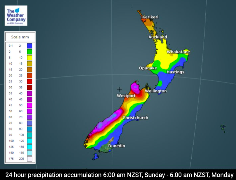
Rain will be heavy on the West Coast, Nelson region and again spilling over into Marlborough. These are the same regions impacted by flooding 9 days ago so there is heightened risk for slips, road closures – and yes, even some flooding (although we expect any potential flooding to be more localised/less widespread).
High pressure today moves out to the east of the country allowing the milder northerly to come in and to let the rain bands from the Tasman Sea move closer to the western side of NZ.
Check your hyper-local WeatherWatch.co.nz forecast to drill down deeper with temperatures, rainfall totals and wind speeds. For even more details (including air pressure, wind gusts, Fog Forecaster and Frost Forecaster) please visit www.RuralWeather.co.nz (a WeatherWatch product powered by IBM).

For hyper-local rainfall numbers where you are located, please use the rainfall data at www.RuralWeather.co.nz


Latest Video

More heavy rain, snow – but large dry areas, especially as we go into the long weekend
Heavy rain will continue for parts of Canterbury and Marlborough over the next day or two and it will gradually…
Related Articles
More heavy rain, snow – but large dry areas, especially as we go into the long weekend
Heavy rain will continue for parts of Canterbury and Marlborough over the next day or two and it will gradually…

Large low brings rain, downpours & some snow – gets colder as the week progresses
Low pressure will cross the upper North Island in the days ahead and that set-up actually pushes more heavy rain…

WeatherWatch App launches real-time local lightning tracker!
A bolt out of the blue! WeatherWatch has launched a live, real-time lightning tracker, enabling Kiwis to gain access to data provided by the…

