
> From the WeatherWatch archives
A very large low continues to affect New Zealand with pockets of damaging weather but as WeatherWatch.co.nz emphasised on Friday, plenty of pockets of sun and calm too.
Heavy downpours, isolated thunderstorms and blustery winds can be expected in several regions over the weekend and early next week – but the size of the low means there are large areas of calm, dry and even sun.
By Sunday night or Monday morning a cold southerly flow will cover the entire country – bringing a much colder week next week to the nation and snow showers around the hills and ranges of the South Island.
As winds change direction following the low crossing, then clearing New Zealand, our mountains and ranges will create sunny and clearing weather for some regions – for example the West Coast on Sunday.
(below from our Friday update)
6am Saturday RAIN map
Very heavy downpours across western and northern regions of the North Island, while a burst of heavy rain tracks southwards down the South Island’s east coast.
6pm Saturday RAIN map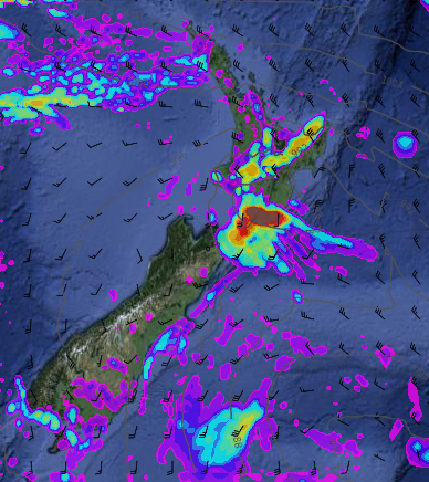
An early burst of downpours for the lower North Island as southerlies start to move up the South Island.
6pm Sunday RAIN map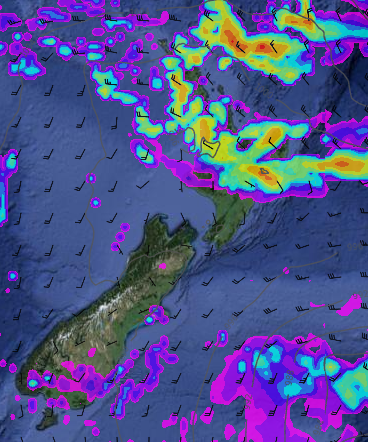
Another burst of rain and isolated heavy falls for the upper North Island. The southerly flow clears showers over the West Coast.
6am Saturday – WIND map
Pockets of potentially damaging winds in purple around the western/north North Island, Cook Strait area and about Banks Peninsula and within the Southern Alps.
6pm Saturday – WIND map
The low off Canterbury’s coast pushes potentially damaging winds into Banks Peninsula and and coastal parts of Canterbury.
6pm Sunday – WIND map
Strong winds blow across the North Island
Tuesday – WIND map
This wind map shows a cold and windy southerly flow across New Zealand – with a large high to the west slowly moving in towards New Zealand, calming things down by Friday and the first weekend of June.
– Maps courtesy Weathermap.co.nz
– WeatherWatch.co.nz
Latest Video

ClimateWatch: JULY outlook & what El Niño means for NZ
El Niño is officially here and still getting stronger in the months ahead, but it’s harder to notice its effects…
Related Articles
ClimateWatch: JULY outlook & what El Niño means for NZ
El Niño is officially here and still getting stronger in the months ahead, but it’s harder to notice its effects…

Low pressure heading to NZ this weekend & into next week
Many regions have settled weather at the moment with frosts as far north as Auckland this morning, but still some…

Colder nights/mornings, polar change coming Sun/Mon
The nights and mornings ahead will be colder in a number of regions – but an even colder change is…

