Storm: Snow update as coldest air starts to arrive (+10 Snow Maps)
27/09/2020 10:59pm

> From the WeatherWatch archives
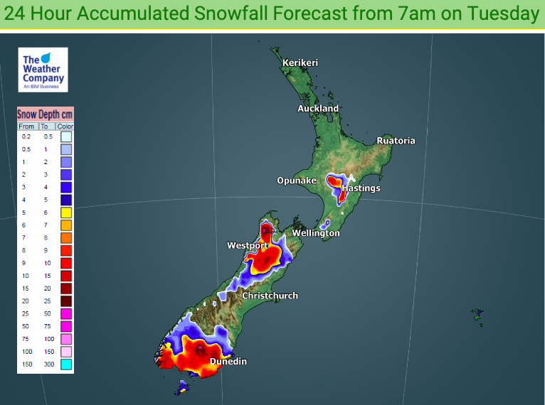
Snow flurries are forecast to sea level in Southland, Otago and Fiordland for a time over the next 48 hours.
For those asking about totals at sea level, it’s harder to work out with precision – this is due to the fact it will have some rain in the mix and surrounded by the sea which is mild in comparison and may help melt snow lower down. The biggest totals will be inland and above 100m.
Snow will also impact the central North Island and Desert Road (State Highway One).
Don’t forget – all the weather data/details you need locally can be found at www.RuralWeather.co.nz including our automatic windchill calculator for every hour over the next 10 full days.


Comments
Latest Video

Wintry weather coming: Snow, rain, wind & sunshine
A cold front is moving into NZ from Friday to Sunday with low pressure developing west of NZ and then…
Related Articles
Wintry weather coming: Snow, rain, wind & sunshine
A cold front is moving into NZ from Friday to Sunday with low pressure developing west of NZ and then…

ClimateWatch: JULY outlook & what El Niño means for NZ
El Niño is officially here and still getting stronger in the months ahead, but it’s harder to notice its effects…

Low pressure heading to NZ this weekend & into next week
Many regions have settled weather at the moment with frosts as far north as Auckland this morning, but still some…


Peter Thomas Langer on 28/09/2020 2:42am
whats the outlook for october and nov will they be wetter up north with a la nina this is more like el nino