Some rain on the way for dry regions + Updated forecast rainfall map
14/12/2019 8:15pm

> From the WeatherWatch archives
NZ is in between high pressure systems this week and on Tuesday a low will pull down sub-tropical fuelled rain over dry upper North Island regions.
WeatherWatch.co.nz says it’s the first forecast of soaking rains in several weeks and for many farmers and growers this is definitely an early Christmas present. The month of November was much warmer and much drier for the top and east of the North Island with mid-summer temperatures burning off moisture before summer had even arrived.
The rain this week will allow farmers, growers and those who rely on rain water to perhaps sleep a little easier at Christmas time and heading into the start of the new year.
WILL IT BE ENOUGH RAIN?
Rainfall totals do vary due to our mountains and ranges and yes, some people may miss out on a true soaking into the soil. But for the most part many places should get some nice rainfall.
Totals are not high for everyone – this doesn’t appear to be a single rain event that reverses the big dry that has formed. Some parts of Waikato, for example, only have 20 to 30mm forecast in total from this event. That is very welcome rain but no way near enough to make up for the deficit. Other areas in the hills or more north facing into the rain bands may get 50 to 100mm.
PAST 24 HOURS RAINFALL
NEXT 72 HOURS RAINFALL (7am Sunday – 7am Wednesday)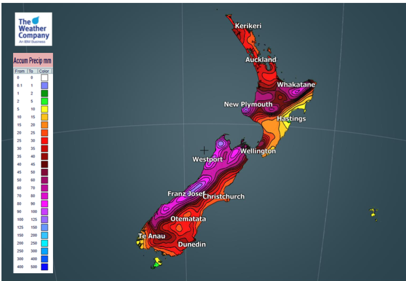
– WeatherWatch.co.nz
Latest Video

Antarctic southerly for parts of NZ Fri & Sat
For the first time this year a southerly from off Antarctica is heading towards the South Island, followed by more…
Related Articles
Antarctic southerly for parts of NZ Fri & Sat
For the first time this year a southerly from off Antarctica is heading towards the South Island, followed by more…

Meteors – Your Eyewitness Reports!
WeatherWatch.co.nz receives meteor reports from all over New Zealand and the globe, 24/7/365. **CASUAL COMMENTS**If you’ve seen something in the…

Snow, rain showers & cold polar southerlies set to return
Friday will be a wintry day across NZ as the next cold front arrives, bringing snow to lower levels of…

