Severe marine heatwave off North Island’s west coast, temps now higher than usual peak of summer – MetOcean
10/12/2021 1:31am

> From the WeatherWatch archives
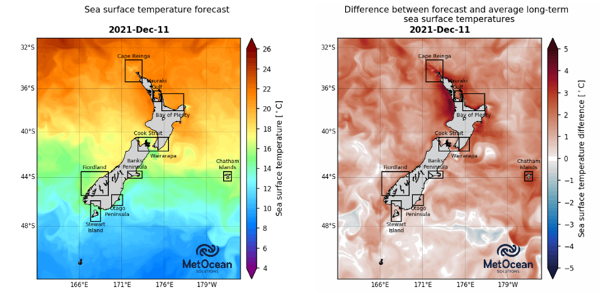
Today and tomorrow (10 and 11 December), the western coastline of the North Island is due to experience water temperatures up to a whopping 4 degrees warmer than normal for this time of year, reports MetOcean Solutions – the oceanographic division of the NZ MetService.
Northland to Taranaki will experience sea temperatures above what is normally experienced even in the peak of summer.
The forecast (image below left) shows expected sea surface temperatures along this stretch of coastline to reach values higher than 22 degrees C, which are approximately 4 degrees C above average temperatures for this time of year (image below right).
MetOcean Solutions run daily marine heatwave forecasts out to 7 days, which are freely accessible on the Moana Project website (https://www.moanaproject.org/marine-heatwave-forecast). The project is a large research endeavour funded by New Zealand’s Ministry for Business, Innovation and Employment (MBIE).
Dr Joao Souza, the Moana Project Science Lead, says, “The right-hand image in the forecast shows the deviation from average sea surface temperatures at this time of year. The forecast for Friday and Saturday is dominated by strong marine heatwaves across the North Island of New Zealand – we rarely see such a large area affected by temperatures 3-5 degrees above average.”
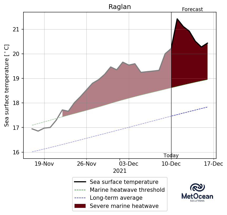
La Niña conditions this summer means we’ll likely see a number of marine heatwaves, however this particular heating event won’t last long. “Our marine heatwave forecast shows the warm water dissipates at the beginning of next week,” continues Dr Souza. “Although marine heatwave conditions may last longer, the temperatures will become more moderate. The short-term nature of the warming indicates that it is likely caused by warm air heating the sea surface, rather than warm water moving south.”
“Marine heatwaves may please beachgoers but continued high temperatures can harm marine organisms. As part of the Moana Project, we are examining the warming at depth, and providing this information to New Zealand’s fisheries and aquaculture sectors to help them manage their marine-based businesses.”
*WeatherWatch.co.nz is proud to support MetOcean and the Moana Project – you can find more about it here.
Latest Video

Westerlies continue, sub-tropical for some
West to north-west winds blow through the South Island and lower North Island today bring heavy West Coast rain and…
Related Articles
Westerlies continue, sub-tropical for some
West to north-west winds blow through the South Island and lower North Island today bring heavy West Coast rain and…

Westerly change this week, unsettled but large dry areas
Westerlies kick back in again this week which will bring a break to those in the east as far as…

Matariki, the long weekend + the outlook for next week
Wet weather and cloud continues along the eastern side of the country with the heaviest rain now moving into northern…

