Severe gales and heavy rain possible this weekend as spring finally wakes up (+2 Maps)
30/10/2018 11:07pm

> From the WeatherWatch archives
We have a spring blast for the first weekend of November and severe weather warnings may be issued. WeatherWatch.co.nz says high pressure will remain to the north of the country this weekend while deep air pressure remains around the Southern Ocean, placing New Zealand directly in a severe squash zone of air pressure – in other words, a blast of strong winds are coming.
The west to north west winds will peak on Saturday PM nationwide and continue across the South Island and lower North Island on Sunday. Severe wind warnings may be issued by Government funded forecaster MetService. Rain warnings may also be issued for the West Coast and surrounds as heavy rain sets in for the weekend.
WeatherWatch.co.nz says the system will ease next week although westerlies look more dominant next week, bringing some more wet weather to the western side of the country but a warmer, drier, week for much of eastern New Zealand.
1PM SATURDAY – RAIN MAP: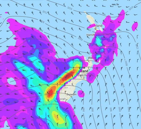
10PM SATURDAY NIGHT – WIND MAP
– Maps by MetOcean – view 10 days of maps via our MAPS tab.
– WeatherWatch.co.nz
Latest Video

Cold weekend, frosts return with high pressure, then a low late next week
The subantarctic airflow spreads over NZ today/tonight and into Saturday, dropping temperatures nationwide. Snow flurries are possible today to lower…
Related Articles
Cold weekend, frosts return with high pressure, then a low late next week
The subantarctic airflow spreads over NZ today/tonight and into Saturday, dropping temperatures nationwide. Snow flurries are possible today to lower…

Wintry burst of weather: Snow, squally showers then sunshine & frosts
A polar change (another one!) arrives on Friday for the South Island and goes nationwide on Saturday, leaving NZ under…

Antarctic southerly for parts of NZ Fri & Sat
For the first time this year a southerly from off Antarctica is heading towards the South Island, followed by more…

