
Donna has a bit of a groove on, bouncing north and south in a wavy fashion as it snaked just north of much of Vanuatu on Friday to lie north west of the island nation on Saturday.
WeatherWatch.co.nz spoke to coastal property owners in Vanuatu two days ago who were expecting the worst. Donna’s wavy tracking has allowed the storm (for now) to bypass most of the populated places.
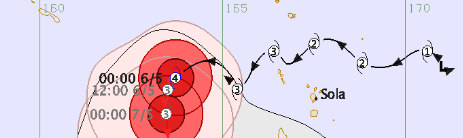
– Tracking over the past few days shows Donna has bounced north and south as she has tracked from east to west. This bouncy behaviour continues over Saturday / Fiji Met
Latest forecast guidance from the global Joint Typhoon Warning Center (US Government) shows that Donna may grow to have sustained winds of 215km/h and gusts to 260km/h today, before weakening gradually from Monday. Donna may hover around a weak Cat 4 and a strong Cat 3 storm for the next day or two before slowly weakening back to Cat 2 towards New Caledonia – at least based on the current best thinking and more reliable models.
Peak wave heights in the storm are now 9 metres. To give you perspective, the average door inside a house is about 2 metres tall.
Tracking a cyclone around small islands is very hard – almost like hitting a hole in one when playing golf. When it’s a larger nation like Australia or the USA then the storm has an enormously greater chance of hitting land.
WeatherWatch.co.nz expects Donna to track offshore to the east of New Zealand next week – but there is still a chance it could connect with another system over New Zealand to create a slow moving band of heavy rain. The good news is that updates over the past three days have indicated the worst of the rain likely to trigger just offshore from East Cape and then may start to move away. We’ll keep you posted with daily updates.
 FIJI MET
 – JTWC
 – Earth
– WeatherWatch.co.nz


Lyn on 6/05/2017 3:29am
Many thanks for your updates – very important for those of us with family and friends living and working in the islands. Lyn H