Severe Cyclone Donna tracking southwards and speeding up
8/05/2017 1:13am

> From the WeatherWatch archives
There’s a good chance Cyclone Donna may have peaked this morning following data from the US Government that suggested Donna temporarily spiked into Category 5 status with winds gusting to 260km/h and peak waves of 10 metres.
The latest update from the Fiji Met Service doesn’t really focus on what has happened over the past six hours, simply a report on conditions at the time of updating and the projection for tracking. It is entirely possible the storm “spiked” to a Category 5 storm even though it officially remains Category 4 in Fiji Met’s latest update.
Cyclones as big as this are constantly changing shape, structure and go through periods of sudden weakening and strengthening and is why in other parts of the western world they have more frequent tropical storm updating.
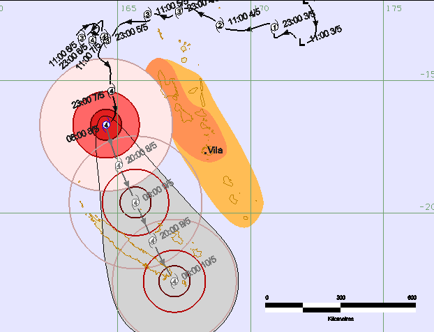
Donna has been slow to track over the past few days, stalling at one point (or moving at slower than human walking speed) after it ‘bounced’ around Vanuatu’s various islands.
This morning, however, the storm deepened further for a time and is now speeding up as it tracks south away from the warmest waters and air. This southern tracking today should indicate that Donna has likely peaked and should very slowly weaken over the next couple of days.
The Fiji Met Service – which only updates once every 6 hours on Donna – didn’t capture the spike detected by American forecasters this morning. As WeatherWatch.co.nz has been saying for many years now, this is one of the issues we have in the South Pacific with limited data and updating.
The Joint Typhoon Warning Centre (JTWC) in the United States indicated Donna peaked this morning and will very slowly weaken over the next few days. JTWC covers global storms all year round.
While the Fiji Met Service is the “official” forecaster (meaning “Government owned”) for Tropical Cyclone Donna, they initially thought Donna would only reach Category 3 and make a more direct hit to Vanuatu. In other words – cyclone tracking can be very tough work and is why WeatherWatch.co.nz relies on additional data with high international standards from the likes of NASA etc, as well as local Government information from Suva and Wellington – to give you as much information as possible.
Official Vanuatu forecasters say Donna may hit New Caledonia as a Cat 4 storm, Fijian forecasters say Cat 2.
Without flying a Hurricane Hunter aircraft into the eye of Donna (as they do with tropical storms in the Atlantic) no one can know for sure what the precise conditions and strength are – we have to rely on computer models and the various (sometimes conflicting) information “officials” drip feed out.
There are still risks for New Zealand – mostly in the form of heavy rain later this week but, as you know well, there is still a lot of uncertainty with the future track of Donna. In fact we think this is harder to track than Cyclone Cook for New Zealand at this stage so check back for updates.
As of 1pm NZT Donna remains a serious Category 4 storm (Fiji Met) packing damaging winds, rain totals of over half a metre and dangerous seas. Fiji Met says Donna has a central air pressure of 948hPa.
 – JTWC
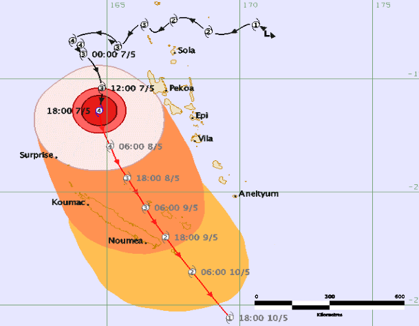
– Fiji Met Service
– Vanuatu Met Service
 Above – Possible tracking of Donna towards NZ showing various computer models – much more uncertainty than with Cyclone Cook but most suggest Donna won’t directly hit NZ, remaining just offshore.
– WeatherWatch.co.nz
Latest Video

Westerlies continue, sub-tropical for some
West to north-west winds blow through the South Island and lower North Island today bring heavy West Coast rain and…
Related Articles
Westerlies continue, sub-tropical for some
West to north-west winds blow through the South Island and lower North Island today bring heavy West Coast rain and…

Westerly change this week, unsettled but large dry areas
Westerlies kick back in again this week which will bring a break to those in the east as far as…

Matariki, the long weekend + the outlook for next week
Wet weather and cloud continues along the eastern side of the country with the heaviest rain now moving into northern…

