Saturday’s national forecast – Low takes hold (+8 maps)
28/05/2021 4:00pm

> From the WeatherWatch archives
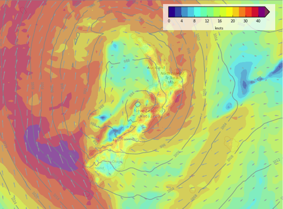
Unsettled for most New Zealand regions today with a deep low pressure system controlling the countries weather and bringing in heavy rain for some regions.
Most regions see rain or showers today, rain may be heavy for some regions.
Please refer to your local, hourly, 10 day forecast for more details.
Northland, Auckland, Waikato & Bay Of Plenty
Rain with a few heavy falls, easing to showers in the afternoon as northerlies tend a little more northwest. There could be a thunderstorm in the morning for Great Barrier Island and the Coromandel then perhaps Northland for a time in the afternoon.
Highs: 15-17
Western North Island (including Central North Island)
Cloudy with rain about Taranaki spreading elsewhere in the morning, there may be a heavy fall or two then easing from the west afternoon onwards. North to northeasterly winds.
Highs: 10-15
Eastern North Island
Some morning sun but expect high cloud to thicken, rain moves over in the afternoon then clears overnight although remaining about Wairarapa. Northeasterly winds freshen then changing northwest around midnight.
Highs: 14-17
Wellington
Cloudy with the odd spit or shower, rain develops in the afternoon, perhaps becoming heavy overnight for a time. Easterlies.
Highs: 13-14
Marlborough & Nelson
Rain, heavy about the northwest Nelson ranges area. Heavy rain spreads into Marlborough late afternoon. East to southeasterly winds. Snow sticks above about 1200 or 1300m.
Highs: 12-13
Canterbury
Showers, perhaps some rain mainly inland. In the evening rain becomes widespread and heavy, especially inland. Southeasterly winds freshen later in the day. Expect heavy snow above 1000m, it may get down to 800m for South Canterbury then lifting a little from evening.
Highs: 8-12
West Coast
Mostly cloudy, the odd spit spreading from the east at times. Expect rain further inland about the Main Divide pushing over from the east, rain becomes heavy from evening about the Main Divide north of the Glaciers with heavy snow down to about 900 or 1000m. Gusty southeasterlies.
Highs: 11-13
Southland & Otago
Cloudy with patchy rain or showers, rain a little more persistent about Central and North Otago. Snow flurries possible to 800m. South to southeasterly winds, freshening a little from afternoon about coastal Southland.
Highs: 8-12


Latest Video

Cold weekend, frosts return with high pressure, then a low late next week
The subantarctic airflow spreads over NZ today/tonight and into Saturday, dropping temperatures nationwide. Snow flurries are possible today to lower…
Related Articles
Cold weekend, frosts return with high pressure, then a low late next week
The subantarctic airflow spreads over NZ today/tonight and into Saturday, dropping temperatures nationwide. Snow flurries are possible today to lower…

Wintry burst of weather: Snow, squally showers then sunshine & frosts
A polar change (another one!) arrives on Friday for the South Island and goes nationwide on Saturday, leaving NZ under…

Antarctic southerly for parts of NZ Fri & Sat
For the first time this year a southerly from off Antarctica is heading towards the South Island, followed by more…

