RainWatch – Heavy showers for the western North Island today
24/08/2020 7:00pm
> From the WeatherWatch archives
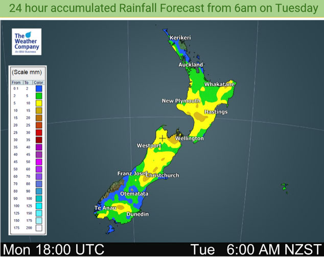
All North Island regions can expect showers today, heavy this morning with possible thunderstorms and hail for western regions north of Taranaki then gradually easing from afternoon as southwesterlies move in. Rain or showers about Southland / Otago spread northwards during the day with cold southwesterlies. Snow lowers on the ranges to 300m about the lower South Island by afternoon then lowering to 400m for Marlborough overnight.
Some morning rain can be expected in the south / east of the North Island on Wednesday with some snow to 500m then clearing in the afternoon. Occasional showers for most other North Island regions. Early rain / snow to 400m about Nelson / Marlborough clears then mainly dry, a shower or two could continue about Tasman / Nelson at times. Showers from afternoon for the West Coast, rain moves into Fiordland from afternoon spreading into North Westland later in the evening. The odd shower about coastal Southland, rain spread northwards through Southland and Otago late afternoon / evening with some snow to 500m then easing overnight.

Expect showers for the western North Island on Thursday, there may even yet again be some thunder / hail then easing mid to late afternoon. The eastern North Island is mainly dry but a brief shower may pass through in the afternoon. Occasional showers for the western and southern South Island, dry elsewhere in the east and north.

For rainfall accumulation maps for 1, 2 and 3 days out please visit our new maps page: https://www.weatherwatch.co.nz/maps-radars/rain/accumulative-rainfall
By Weather Analyst Aaron Wilkinson – WeatherWatch.co.nz
Latest Video

Slow moving low to track over northern NZ
A low pressure zone will slowly cross the North Island over the coming days, bringing hit and miss pockets of…
Related Articles
Slow moving low to track over northern NZ
A low pressure zone will slowly cross the North Island over the coming days, bringing hit and miss pockets of…

NI low pressure, SI polar change
Low pressure will move over the upper North Island this week, bringing hit and miss pockets of heavier rain into…

Rain & showers this weekend, colder change next week
Some places will warm up over the next day or so as a nor’wester out of Australia moves across NZ,…

