RainWatch for Tuesday / Wednesday + 7 day rain map
20/04/2020 3:33am

> From the WeatherWatch archives
Mainly dry for the North Island on Tuesday, expect a few showers to affect northeastern parts of Northland however. The South Island is mainly dry also but expect showers for South Westland, these push northwards along the coast overnight.
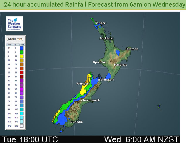
Mainly dry weather continues for the North Island on Wednesday, just the odd light shower possible about the extremities. The South Island continues to have a few showers in the west, mainly dry out east.
The long range outlook for the next 7 days suggests some wet weather incoming for the North Island, this is likely to be during the second half of Thursday as a front moves in from the Tasman Sea, high totals are not expected but anything is starting to become welcome for those in the north. Showers or rain continues off and on for the West Coast of the South Island, mainly dry conditions persist in the east.

For rainfall accumulation maps for 1, 2 and 3 days out please visit our new maps page: https://www.weatherwatch.co.nz/maps-radars/rain/accumulative-rainfall
By Weather Analyst Aaron Wilkinson – WeatherWatch.co.nz
Latest Video

Antarctic southerly for parts of NZ Fri & Sat
For the first time this year a southerly from off Antarctica is heading towards the South Island, followed by more…
Related Articles
Antarctic southerly for parts of NZ Fri & Sat
For the first time this year a southerly from off Antarctica is heading towards the South Island, followed by more…

Meteors – Your Eyewitness Reports!
WeatherWatch.co.nz receives meteor reports from all over New Zealand and the globe, 24/7/365. **CASUAL COMMENTS**If you’ve seen something in the…

Snow, rain showers & cold polar southerlies set to return
Friday will be a wintry day across NZ as the next cold front arrives, bringing snow to lower levels of…

