
> From the WeatherWatch archives
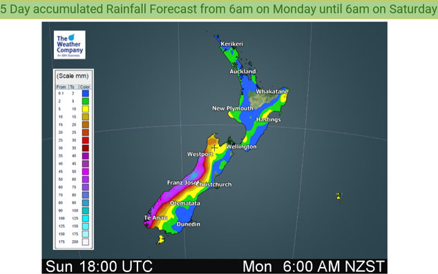
An easterly quarter airflow lies over the North Island on Tuesday and this brings the odd shower to east / northeastern areas. Mainly dry conditions in the west. For the South Island a front coming out of a low in the Tasman Sea brings rain to the West Coast as can be seen below, a few spits or showers may spread further eastwards.
A similar situation continues on Wednesday for the North Island meanwhile further south the aforementioned front slips a little further southwards along the West Coast and weakens.

This coming Thursday and incoming system from the southwest brings heavy rain to the West Coast of the South Island, this front moves onto the western North Island on Friday but it does weaken.
For rainfall accumulation maps for 1, 2 and 3 days out please visit our new maps page: https://www.weatherwatch.co.nz/maps-radars/rain/accumulative-rainfall
By Weather Analyst Aaron Wilkinson – WeatherWatch.co.nz
Latest Video

Antarctic southerly for parts of NZ Fri & Sat
For the first time this year a southerly from off Antarctica is heading towards the South Island, followed by more…
Related Articles
Antarctic southerly for parts of NZ Fri & Sat
For the first time this year a southerly from off Antarctica is heading towards the South Island, followed by more…

Meteors – Your Eyewitness Reports!
WeatherWatch.co.nz receives meteor reports from all over New Zealand and the globe, 24/7/365. **CASUAL COMMENTS**If you’ve seen something in the…

Snow, rain showers & cold polar southerlies set to return
Friday will be a wintry day across NZ as the next cold front arrives, bringing snow to lower levels of…

