Rainfall outlook: How much has fallen and what is coming this week (+9 Maps)
8/11/2020 7:26pm

> From the WeatherWatch archives
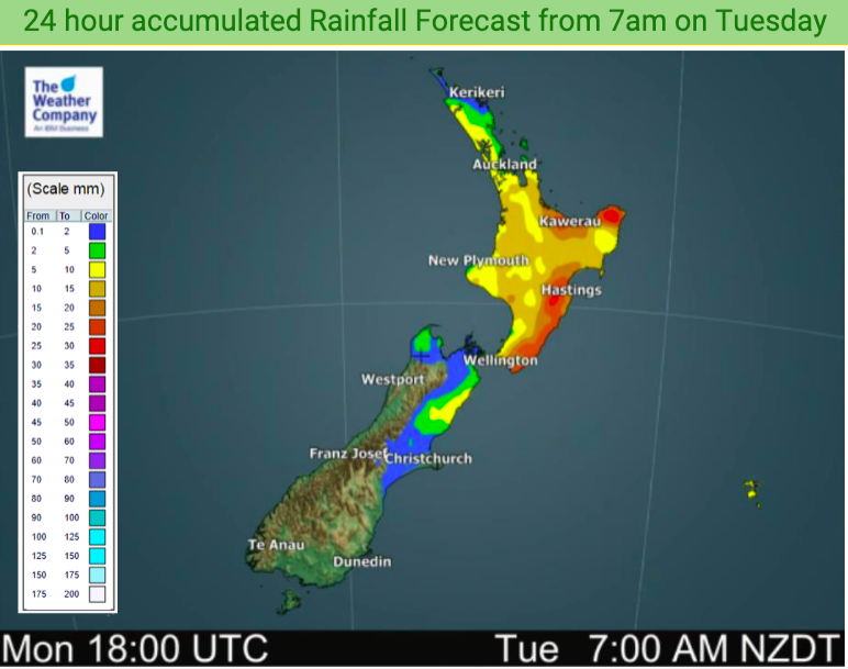
Over 100mm may be coming for central and southern Hawke’s Bay while thunderstorms and isolated downpours may bubble up over other parts of northern New Zealand.
The rain and thunderstorms that have fallen in the past day or two will continue around various North Island regions (and the upper South Island for a time too). Biggest downpours will be in the mid to later afternoon hours and very early evening.
It’s due to a low pressure system which has stalled over the North Island and will remain so until Wednesday. A southerly flow over the South Island is feeding into the low.
The low clears away on Wednesday night and high pressure returns to many places.
As always, refer to your local HOURLY forecasts for your local rainfall totals and to drill down even deeper visit www.RuralWeather.co.nz – it’s NZ’s largest weather data website!


Latest Video

Cold weekend, frosts return with high pressure, then a low late next week
The subantarctic airflow spreads over NZ today/tonight and into Saturday, dropping temperatures nationwide. Snow flurries are possible today to lower…
Related Articles
Cold weekend, frosts return with high pressure, then a low late next week
The subantarctic airflow spreads over NZ today/tonight and into Saturday, dropping temperatures nationwide. Snow flurries are possible today to lower…

Wintry burst of weather: Snow, squally showers then sunshine & frosts
A polar change (another one!) arrives on Friday for the South Island and goes nationwide on Saturday, leaving NZ under…

Antarctic southerly for parts of NZ Fri & Sat
For the first time this year a southerly from off Antarctica is heading towards the South Island, followed by more…

