Powerful Gita crosses southern Tonga, now out to open waters and later the Tasman Sea
12/02/2018 5:10pm

> From the WeatherWatch archives
Powerful Cyclone Gita is now starting to move away from Tonga after a night of ferocious weather with winds estimated to be sustained at 230km/h and gusts to 280km/h at the centre of the storm and huge seas creating waves over 11 metres.
In summer Tonga shares the same time zone as New Zealand and we expect the worst to be fast easing from 7am as the storm tracks westwards quickly away the nation island chain.
Gita remained a powerful Category 4 storm overnight (there is little difference between a powerful Category 4 storm and a ‘low end’ Category 5).
The eyewall of Gita – the most powerful part of the storm – did brush the main island of Tongatapu so damage is expected to be significant for some.
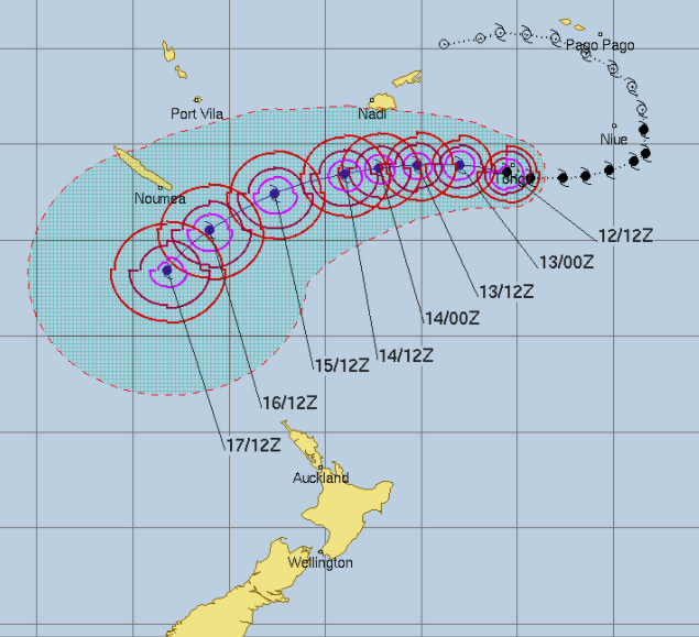
The storm will next cross over a small Fijian island chain called Ono-I-Lau where families have been evacuated.
Beyond that, over the next day or two, there won’t be as much news on the storm as it tracks over open waters towards New Caledonia and Norfolk Island. It is still forecast to grow into a Category 5 cylone.
NEW ZEALAND’S RISK
Computer models have been agreeing for days that Cyclone Gita will swing out into the Tasman Sea then curve back around and make a direct hit into New Zealand (by then as an ex-cyclone).
What still remains unclear is precisely where in New Zealand it will come in to – but most likely the western side of New Zealand. It’s also unclear if it will still retain storm conditions (ie, severe weather) by then, or just a weaker area of low pressure.
Rain from Gita looks quite likely for parts of New Zealand as early as this weekend and into next week.
As for timing, the numerous reliable models that accurately picked this storm a couple of weeks ago are still not in agreement for New Zealand specifically, with times of a potential landfall here varying from late this coming weekend to mid next week (Sunday to Wednesday). Next week is looking most likely – but we’ll keep you posted this week as we get more confident.
– WeatherWatch.co.nz
The center of Severe Tropical Cyclone #Gita appeared to be gyrating in a trochoidal motion but wobbled close enough for the eyewall(s) to hit Tongatapu, the most populous island of #Tonga pic.twitter.com/td1l0FwxrC
— Stu Ostro (@StuOstro) February 12, 2018
Latest Video

Westerlies continue, sub-tropical for some
West to north-west winds blow through the South Island and lower North Island today bring heavy West Coast rain and…
Related Articles
Westerlies continue, sub-tropical for some
West to north-west winds blow through the South Island and lower North Island today bring heavy West Coast rain and…

Westerly change this week, unsettled but large dry areas
Westerlies kick back in again this week which will bring a break to those in the east as far as…

Matariki, the long weekend + the outlook for next week
Wet weather and cloud continues along the eastern side of the country with the heaviest rain now moving into northern…

