
> From the WeatherWatch archives
Severe Tropical Cyclone Yasi continues to push out into the open waters over the Coral Sea as it races towards Cairns and the Queensland Coast.
The cyclone continues to track in a westerly direction but should start to take a slightly more south west direction overnight tonight.
We have extensive coverage of Yasi, including the latest forecast maps and satellite images.
 Yasi is currently a Category 3 tropical cyclone with winds averaging 155km/h and gusting to 220km/h.
Image : Infrared satellite map of Yasi today / MTSAT
It is racing towards Queensland at 33km/h and this fast movement will help push up the winds in front of it (but decrease them a bit behind it).
The air pressure is 960hPa but is predicted to fall in to 938hPa late tomorrow predicts Australia’s Bureau of Meteorology (BoM).
Meanwhile BoM is using strong language in their latest shipping forecast, saying the Yasi is creating “phenomenal seas” around the centre of the low stretching as far as 75kms.
WeatherWatch.co.nz says these incredible seas could pose a serious risk to the fragile Great Barrier Reef which lies directly in its path. The weather news authority says Yasi may cause damage that will take years if not decades to repair.
However WeatherWatch.co.nz says the estimated arrival time for Yasi to make landfall could be favourable with the sea heading towards low tide as the eye makes landfall, which could reduce the storm surge.

Predicted swells around 10pm on Wednesday as Yasi moves in. Orange indicates 3 metre swells, purple at least 8 metres. Image / Weathermap.co.nz
WeatherWatch.co.nz says that while Yasi has the same strength as Wilma it is much bigger in size.
Wilma is about 2500kms in diameter. To compare, New Zealand is just 1500kms long.
As of 4pm NZT Yasi remained 1300kms east of Cairns.
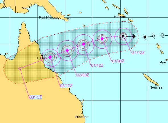
Here is the latest track prediction for Severe Tropical Cyclone Yasi, issued by BoM.

Predicted tracking by the Joint Typhoon Warning Centre
.jpg)
Yasi late this morning / Google Earth
Comments
Latest Video

Wintry change coming for SI and lower NI
Some wet weather, along with a drop in temperatures, will move into the lower South Island later on Sunday and…
Related Articles

ClimateWatch: JUNE outlook as El Niño continues to build
June has kicked off in NEUTRAL again as far as El Niño is concerned, but it is expected to form…

ClimateWatch: May outlook & El Niño discussion
Everyone is talking about El Niño so in this month’s update we discuss when it may be forming and what…

Wed April 29 – No video today sorry!
Apologies but due to some tech hassles with our camera (and a fairly quiet weather forecast) we don’t have an…


Guest on 2/02/2011 7:55am
Hi all,
The ABC is running continuous coverage on TC Yasi. Can probably see it at abc.net.au/news
-Kris from Oz
Guest on 1/02/2011 11:53am
Hi there is this going to hit New Zealand at all!!!!!!!
WW Forecast Team on 1/02/2011 5:55pm
No it won’t luckily. Yasi is going to make landfall in Queensland and in a couple of days it will hardly even register as a low let alone a cyclone.
– WW
Guest on 1/02/2011 8:47am
What do you reckon – a 50% chance of Cat 5 before landfall?
SST’s are a little lower – but not really low enough to stall growth – just slow it a bit. And everything upstairs seems to be in order…
WW Forecast Team on 1/02/2011 9:02am
We said last week that it may touch Cat 5 and we still believe that, despite – as you say – it being a bit slow. It will certainly be a very powerful storm when it makes landfall. Looks very ominous on the maps tonight.
– WeatherWatch
View more comments