NZ’s Upcoming Rain: 1-Day, 3-Day and 5-Day rainfall outlooks (+5 Maps)
24/02/2020 1:59am

> From the WeatherWatch archives
It may feel like a touch of Autumn today but summer’s heat and humidity is not over and this week downpours return.
Some may be heavy through the North Island’s interior and create thunderstorms – as we saw on Sunday.
The West Coast has rain this week driven by westerlies, whereas the North Island has isolated downpours, drizzle and showers later this week delivered by more humid east to north east winds.
Compared to what has previously fallen at this time of year, many parts of NZ will lean drier than average this week – but the positive news for the drought zones is that repeat downpours may start to really help, but for that to happen they really need to occur in the same place.


NEXT 5 DAYS (to 7am Saturday)
NEXT 7 DAYS RAINFALL COMPARED TO NORMAL FOR THIS TIME OF YEAR (US Govt)
Red = Drier than normal. White = Average rainfall. Blue = Wetter than usual.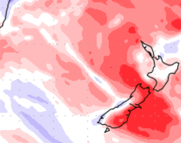

– WeatherWatch.co.nz for news, maps and videos. www.RuralWeather.co.nz for the largest NZ weather data page on earth.
Latest Video

Antarctic southerly for parts of NZ Fri & Sat
For the first time this year a southerly from off Antarctica is heading towards the South Island, followed by more…
Related Articles
Antarctic southerly for parts of NZ Fri & Sat
For the first time this year a southerly from off Antarctica is heading towards the South Island, followed by more…

Meteors – Your Eyewitness Reports!
WeatherWatch.co.nz receives meteor reports from all over New Zealand and the globe, 24/7/365. **CASUAL COMMENTS**If you’ve seen something in the…

Snow, rain showers & cold polar southerlies set to return
Friday will be a wintry day across NZ as the next cold front arrives, bringing snow to lower levels of…

