Weather to Jan 31: Windy, cooler, weekend – then winds ease but daytime downpours likely
22/01/2026 11:43pm
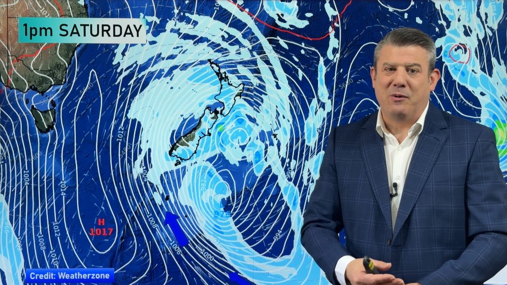
It will be a windy weekend for a number of regions, with showers, some heavy with isolated thunderstorms developing over both islands today and over the days ahead – but dry and calmer areas are also in the mix. This weekend is especially windy around the North Island and for a time in the lower South Island. We break it down for you as there are a lot of moving parts (hence the longer runtime of our video today – normally we aim for 8 minute updates).
Next week the low finally moves off NZ and winds become lighter in many places as higher air pressure moves in – but with that comes the added risk of daytime thunderstorms and downpours, especially inland areas. Not everyone will get them due to our mountains and ranges breaking up the flow, but we show you the main risk areas… finer tuning of these forecasts will be done on Tuesday (Programming Note, due to Auckland Anniversary we have no video update on Monday).
We have NZ’s rainfall outlook to Sunday night and then the longer range outlook to January 31 as high pressure returns – but it’s not very powerful and we may still get some cooler air and showers later in the week. NZ is still going to get more wet weather in the final week of January – but some large dry areas in the mix too.
Comments
Latest Video

Polar airflows set to bring cold weekend to NZ
Nor-west winds will be building over parts of NZ going into Thursday with rain on the West Coast becoming heavy…
Related Articles

NZ: Cold & windy, then calm & frosty
Downpours, some squally with the chance of thunderstorms and even small tornadoes are possible for parts of NZ over Friday…

WeatherWatch App launches real-time local lightning tracker
A bolt out of the blue! WeatherWatch has launched a live, real-time lightning tracker, enabling Kiwis to gain access to data provided by the…

Wind, rain, showers & a noticeable temperature drop for all
It will be a colder weekend right across NZ as a sub-Antarctic southerly blows through, bringing frosts, snow flurries and…


Andrew on 23/01/2026 2:36am
A few choppy days ahead.
Would be great to see this type of situation in July. Not often anticyclones drag air up from that far south.