
> From the WeatherWatch archives
Tuesday Nov. 3 — Sub-tropical airflows and a developing low in the north may bring some much need rain in the coming days.
Both islands are exposed to rain with the north and north east facing parts of the upper North Island most exposed to the low which will develop and brush northern NZ on Thursday.
On Thursday night this low will hug Northland and Auckland – finally bringing some relief to dry parts of these regions. The Coromandel and Kaimai Ranges will limit some of this rain into the Hunua Ranges water catchment area for Auckland. Despite that, WeatherWatch.co.nz expects 20 to 40mm over the Hunua Ranges which will be helpful. Not close to reversing the problems but certainly enough to noticeably help. Perhaps more importantly, the rain will be very welcome by gardeners, farmers, growers and those on rain/roof water.
The rain will also slide into Bay of Plenty and East Cape with some heavy falls as this low moves by on Thursday night.
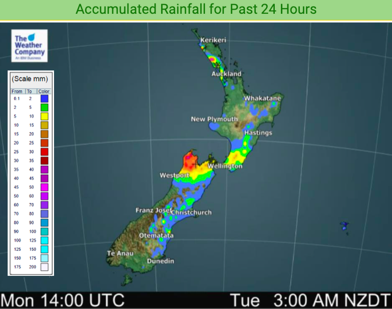
Heavy downpours will also lock in to the West Coast over the next 48 hours.


Latest Video

Antarctic southerly for parts of NZ Fri & Sat
For the first time this year a southerly from off Antarctica is heading towards the South Island, followed by more…
Related Articles
Antarctic southerly for parts of NZ Fri & Sat
For the first time this year a southerly from off Antarctica is heading towards the South Island, followed by more…

Meteors – Your Eyewitness Reports!
WeatherWatch.co.nz receives meteor reports from all over New Zealand and the globe, 24/7/365. **CASUAL COMMENTS**If you’ve seen something in the…

Snow, rain showers & cold polar southerlies set to return
Friday will be a wintry day across NZ as the next cold front arrives, bringing snow to lower levels of…

