NZ: Autumn weather is here with another cool down coming this week (+4 Maps)
8/03/2020 10:15pm

> From the WeatherWatch archives
Many argue over the precise starting point of a season but WeatherWatch.co.nz follows Mother Nature’s weather patterns and based on that Autumn is already here.
The meteorological start to Autumn was March 1. The astronomical start date this year is March 20th. However the weather pattern is already sliding out of the summer one and we can measure that in a couple ways.
- NZ is finally getting breaks between the highs now, bringing in a weekly chance for wet weather in both islands.
- NZ is now getting the ups and downs with temperatures. Not every day is hot with below normal southerlies sliding in more often.
The cool southerly change this week will spread up New Zealand over Tuesday and Wednesday before fading and being replaced by warmer than average weather again this coming weekend.
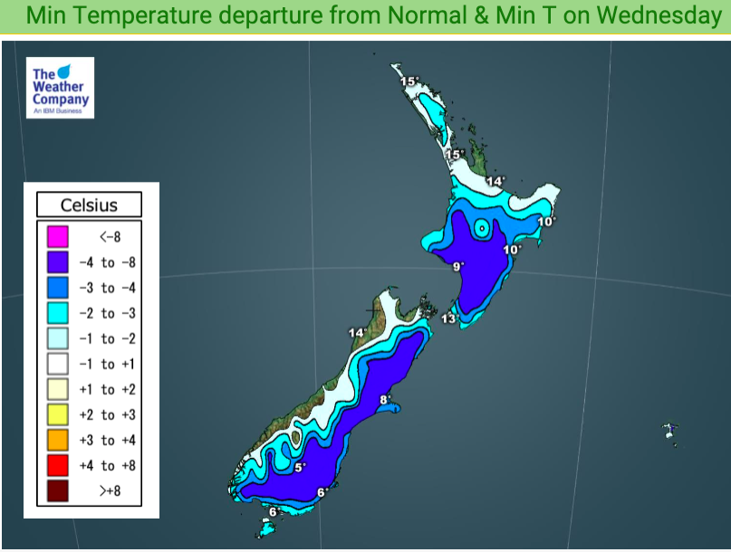
Just like last week, the temperature reset this week will be most felt over the South Island and lower and eastern North Island. Northern NZ will barely be impacted, if at all.
But daytime highs on Tuesday or Wednesday will be well down in many areas on today’s highs – some by almost 10 degrees. Main examples…
- Dunedin: 22 today, 14 Tuesday & Wednesday.
- Queenstown: 19 today, 13 on Tuesday
- Alexandra: 23 today, 14 on Tuesday
- Christchurch: 28 today, 16 Tuesday, 15 Wednesday.
- Blenheim: 24 today, 18 Wednesday
- Wellington: 19 today, 16 by Wednesday.
- Hastings: 25 today, 19 by Wednesday.
- Gisborne: 25 today, 18 by Thursday.
SOUTH ISLAND FROST OR ICE
By Tuesday and Wednesday nights we may be seeing temperatures close to freezing with light frosts possible well inland in the South Island and ice on car roofs likely on Wednesday morning in places like northern Southland, inland Otago and the high country of Canterbury. Soil temperatures may be too high to let frosts form on the ground but either way overnight lows will be between +1 and +4 in a number of places in the next few nights ahead.


WeatherWatch.co.nz Exclusive
Comments
Before you add a new comment, take note this story was published on 8 Mar 2020.


Add new comment