Northern low on the way with 100mm possible in some dry eastern regions (+13 maps)
13/09/2021 7:13pm

> From the WeatherWatch archives
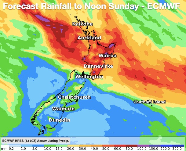
A new low is about to move in to northern NZ from the north west and bring heavy eastern rain while it does so, good news for Hawke’s Bay which is much drier than usual and could do with the wet weather.
Rainfall accumulations are moving around a bit and we strongly advise people to keep up to date with www.RuralWeather.co.nz and WeatherWatch.co.nz hyper-local rainfall totals. These are the most accurate rain forecasts in NZ, powered by IBM. Also, keep up to date with any MetService watches and warnings – these can now be found LIVE on the WeatherWatch website here.
We do expect so changes in the forecast rainfall totals in the coming 24 hours as the system moves closer and our IBM computer modelling fine tunes expected rainfall coupled with how localised terrain (hills, ranges etc) may increase or decrease those forecast totals. In NZ this is always the main reason rain forecasts can shift around a bit.
Latest estimates WeatherWatch has show 60 to 100mm possible along the eastern North Island over the days ahead – rainfall totals vary across the region and those in the ranges will likely have greater totals than those on the plains. Some localised areas my receive 100 to 150mm. Also, Northern Hawke’s Bay may have twice the totals of those further south.
Rain will fall across the North Island and into the upper South Island too.


Latest Video

NI low pressure, SI polar change
Low pressure will move over the upper North Island this week, bringing hit and miss pockets of heavier rain into…
Related Articles
NI low pressure, SI polar change
Low pressure will move over the upper North Island this week, bringing hit and miss pockets of heavier rain into…

Rain & showers this weekend, colder change next week
Some places will warm up over the next day or so as a nor’wester out of Australia moves across NZ,…

Temperature changes for some regions ahead of heavy West Coast rain
A nor-wester is about to kick in and it’s coming from out of Australia, boosting temperatures in some regions going…

