Next week: Two more storms bring gales and heavy rain (+2 Maps)
30/05/2019 11:23pm

> From the WeatherWatch archives
After five months of frequent calm and dry weather NZ’s weather pattern has been turned upside down today and will do so again next week – twice.
The main blast of wind and cold air is yet to reach northern New Zealand and will do so tonight and across Saturday. Gusts around places like Auckland may reach power cut potential for some places overnight but at this stage we expect any issues to be isolated.
Many regions have wind and squally wintry showers with hail over Saturday and Sunday then quickly easing and improving across Monday and Tuesday.
But, next week sees two more storms coming in and both have powercut and flood potential.
The first one comes in on Wednesday and the warm sub-tropical wind flow ahead of it will be felt on Tuesday in the upper North Island. Wednesday, however, looks wet and windy across much of the country as this large low – fed by sub-tropical air – expands across NZ. It will linger until Thursday then clears away.
By next Friday another cold front may be rushing in and data strongly has supported (for days now) a period of gale force west to south west winds and more heavy rain. WeatherWatch.co.nz has already advised utilities in Auckland of possible power outages one week from now as this blast of windy weather comes in. It may well affect other regions too with a lot of moving parts yet to be locked in.
High pressure – with calm, dry and sunnier weather – looks increasingly likely to arrive in 10 days from now. Hopefully in time for Fieldays at Mystery Creek in Waikato.
NEXT WEDNESDAY: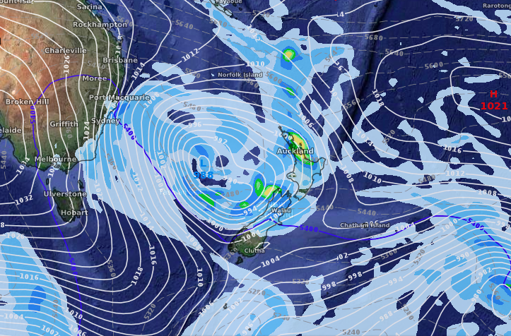
NEXT FRIDAY:
– WeatherWatch.co.nz
Latest Video

Slow moving low to track over northern NZ
A low pressure zone will slowly cross the North Island over the coming days, bringing hit and miss pockets of…
Related Articles
Slow moving low to track over northern NZ
A low pressure zone will slowly cross the North Island over the coming days, bringing hit and miss pockets of…

NI low pressure, SI polar change
Low pressure will move over the upper North Island this week, bringing hit and miss pockets of heavier rain into…

Rain & showers this weekend, colder change next week
Some places will warm up over the next day or so as a nor’wester out of Australia moves across NZ,…

