Monday’s national forecast – Front moves onto the South Island
26/06/2022 12:00pm
> From the WeatherWatch archives
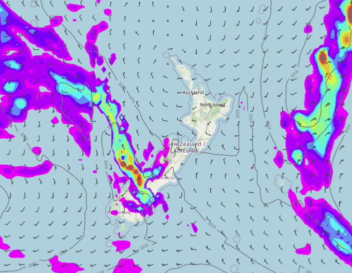
A front moves onto the lower South Island this morning, gradually pushing northwards during the day. The North Island is settled with high pressure.
North Island
Morning fog for the western and upper North Island, mainly inland then clearing to a mix of sun and cloud, some high cloud moves in from the west afternoon on wards. A mainly sunny day for the east coast and Bay Of Plenty with some high cloud later in the day. Winds tend southwesterly in the west, light winds in the east.
South Island
Cloudy for the West Coast, rain about Fiordland with the odd heavy fall, moving northwards to reach North Westland later in the day / overnight. Sun and increasing high cloud for Nelson and Marlborough, southwesterlies for Nelson, west to northwesterly winds for Marlborough. Rain moves into Southland this morning (easing / clearing this afternoon or evening), reaching Otago by midday, South Canterbury in the afternoon and North Canterbury overnight. Snow lowers to 500m at night for Otago and South Canterbury, 700m overnight for North Canterbury. South to southwesterly winds push northwards in the east.
Comments
Latest Video

Large low brings rain, downpours & some snow – gets colder as the week progresses
Low pressure will cross the upper North Island in the days ahead and that set-up actually pushes more heavy rain…
Related Articles
Large low brings rain, downpours & some snow – gets colder as the week progresses
Low pressure will cross the upper North Island in the days ahead and that set-up actually pushes more heavy rain…

WeatherWatch App launches real-time local lightning tracker!
A bolt out of the blue! WeatherWatch has launched a live, real-time lightning tracker, enabling Kiwis to gain access to data provided by the…

Polar airflow + northern low = pockets of heavy rain & snow
A colder change is coming – and so too is a large low which will develop and grow over northern…


janet on 27/06/2022 5:00am
where is the update for tuesday 27th june please
WW Forecast Team on 27/06/2022 8:47am
Hi there, our next video update will be on Tuesday 27th late morning or around noon.
Cheers
WW