Lusi strengthening further today – landfall in New Zealand this weekend (+3 maps)
11/03/2014 9:02pm

> From the WeatherWatch archives
UPDATED 9:53am — Tropical Cyclone Lusi remains a strong Category 2 cyclone this morning and is likely to today reach Cat 3 strength by this afternoon as it moves away from Vanuatu and into the warm open waters of the Pacific.
Media reports yesterday say the storm has already killed one person in Vanuatu.
Data – which has been consistent about tracking this storm for 10 days now – suggests it is most likely to makie landfall in, or very near to, Auckland or Northland either late Sat PM/early Sunday AM.
The centre of the low is where the strongest winds are. Should the centre of the low come in towards Auckland over the Hauraki Gulf it means the low will unlikely weaken a great deal due to that body of water – it means areas like the eastern Waikato will be very exposed damaging winds, Auckland may have storm surges and a period of severe gales and Northland might see wind and rain damage combined.
The centre of the storm also has a storm surge – which could add to coastal flooding if the storm makes landfall during high tide.
TIMINGS
We are being inundated with questions about the timing. No one can be specific on this yet – but roughly:
- Sat PM/early SundayAM the ex-cyclone makes landfall somewhere around Auckland/Northland/Coromandel Peninsula.
- On Sunday the centre of the low will track southwards down the North Island. The weather ahead of it – a bit of wind and rain – will move into northern and eastern parts of the South Island.
- Around noon Sunday the centre of the low may be around Taranaki/Wanganui area with severe weather possibly impacting parts of central NZ, however the storm is slowly starting to unwind now.
- By Sunday night it will be crossing Wellington in a weaker state – but gales and heavy rain still possible. By Sunday PM strong winds and rain may also move into Canterbury.
- By noon Monday the storm falls apart almost completely well east of the South Island out in the Pacific Ocean.
SOUTH ISLAND
The ex-cyclone may well affect Nelson, Marlborough and Canterbury at this stage – but it’s unclear if the weather will be severe. Rain is likely for dry parts of Marlborough and Canterbury, which will be welcome. We’ll let you know if we see something more severe moving into the South Island. For those south of those regions, this system is unlikely to have very much impact on you.
DETAILED FORECASTS
The 7 main centres which we do detailed forecasts for are very much regional forecasts at the moment. For example, Hamilton talks about the Kaimai Ranges. Palmerston North talks about the ranges. And Wellington mentions wind risks for Kapiti.
Auckland, Tauranga, Hamilton, Palmerston North, Wellington, Christchurch and Dunedin have detailed forecasts – and for the North Island centres those forecasts extend region wide at the moment.
FLYING
WeatherWatch.co.nz says some regional flights may be impacted by Lusi. Highest risk for weather related flight delays falls over Saturday and Sunday, mostly North Island. It is very hard to make a prediction about which airports/flights might be affected and when. The airlines and airports themselves will monitor conditions as Lusi moves in – please check with them for further information before your scheduled flight. International flights are often less impacted due to bigger planes with better equipment – but if conditions get dangerous for ground crews then delays can impact all flights.
ADDITIONAL INFORMATION
If you’re wanting more specific rain, wind or swell forecasts for your location this weekend, please use the MAPS link at the top of the page.

Latest tracking map – Fiji Met Service
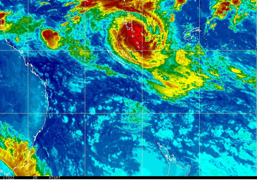
Latest sat map / NOAA / MTSAT shows Lusi over Vanuatu. (NZ bottom centre)
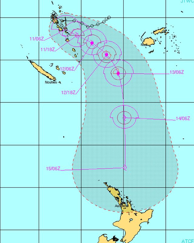
Latest tracking of Cyclone Lusi from JTWC
– WeatherWatch.co.nz
Comments
Latest Video

Frosts, clearer skies coming – severe weather possible this weekend
High pressure lies south of NZ today and that placement encourages a colder south-east wind into the North Island bringing…
Related Articles
Frosts, clearer skies coming – severe weather possible this weekend
High pressure lies south of NZ today and that placement encourages a colder south-east wind into the North Island bringing…

NZ: 8 Day outlook as gales & rain ease, high pressure builds
Damaging wind gusts and heavy rain will continue to affect some parts of the North Island and brushing Marlborough today…

Pockets of hit & miss heavy rain, snow moves northwards
Low pressure continues to slowly move across the upper North Island and for some that will bring the sun out,…


Alan on 12/03/2014 3:16am
Hi Duncan
I have a bit of a vineyard tour on this Saturday 9-4 and have seen mixed views on the likely weather for the day. What is your best guess at this stage? Thanks
WW Forecast Team on 12/03/2014 5:06am
Hi Alan, the day starts off dry according to the latest data – but we can see either an area of rain or showers moving in late morning/early afternoon – and it might set in. Confidence is 50/50 though which is why you’ve seen mixed views. Our data says a 40% chance of rain moving in from the north with ESE winds, then rising to 60% chance later in the day. Good luck.
– WW team
View more comments