INDIA: Extremely Severe Cyclonic Storm VAYU will it or won’t it make landfall? (+15 Maps)
13/06/2019 12:37am

> From the WeatherWatch archives
UPDATED 12:35pm NZT / 6:05am IST — Just minutes after our first update today on Cyclone VAYU forecasters at the Joint Typhoon Warning Center updated the forecast tracking – and by quite a bit. The change to the forecast track may have a significant impact on the forecast for India (a more positive one). In saying that, modelling remains somewhat conflicted about precise timing and if landfall will occur – or if the storm may now veer to the west away from land.
Below is the latest tracking map for VAYU – and is now an ESCS storm (Extremely Severe Cyclonic Storm) with 500mm forecast along with 200km/h gusts and waves over 9 metres. However if the storm veers more to the west it will reduce these values for India.
WeatherWatch.co.nz says Vayu is a serious storm and brings dangerous seas, destructive winds and flooding rains but the precise tracking is changing. *IF IN INDIA PLEASE KEEP UP TO DATE WITH LOCAL INDIAN AUTHORITIES*.
CURRENTLY:
- About 300 km west of Mumbai
- Max sustained wind is around 170km/h gusting over 200km/h.
FORECAST:
- The ESCS will move north-northwestward with maintaining or slightly strengthening its power over the next 24 hours.
- Vayu’s track forecast is as follows (According to JTWC) the ESCS will travel northwest along the coastline off Kathiawar Peninsula – PLEASE NOTE THIS TRACKING HAS NOT BEEN CONFIRMED AND RECENT MAPS SHOW IT MOVING MORE TO THE WEST.
IMPACTS – THESE VALUES/NUMBERS ARE BASED ON IF VAYU MAKES LANDFALL – if the storm veers to the west further then the impacts will be lessened:
- Total rainfall will reach to 500 mm or more between Dwarka and Porbandar in Kathiawar peninsula, Gujarat for next four days.
- From Thursday before noon to afternoon if landfall, Wind speeds of up to 160 km / h can occur between Kodinar and Veraval.
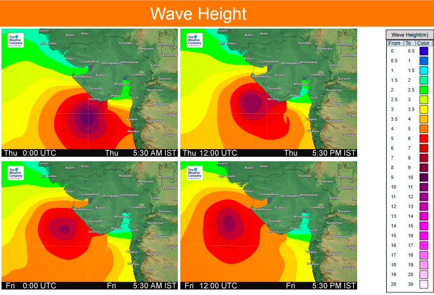
- Up to 9 m waves are expected off Veraval from Thursday before noon to afternoon.
LATEST TRACKING AS OF 12:30PM THURSDAY NZT / 6AM THURSDAY IST – Tracking via JTWC (USA)
PREVIOUS UPDATE **PLEASE NOTE THE DATA BELOW IS BASED ON VAYU MAKING LANDFALL – some modelling now suggests this is less likely. PLEASE pay attention to local Indian authorities for local official weather warnings specific to your area.


WIND SPEED ESTIMATES JUST BEFORE, DURING, AND SHORTLY AFTER MAKING LANDFALL:
– WeatherWatch.co.nz, proudly an official global partner to IBM & TWC
Latest Video

Wintry weather coming: Snow, rain, wind & sunshine
A cold front is moving into NZ from Friday to Sunday with low pressure developing west of NZ and then…
Related Articles

WeatherWatch App launches real-time local lightning tracker!
A bolt out of the blue! WeatherWatch has launched a live, real-time lightning tracker, enabling Kiwis to gain access to data provided by the…

Polar airflow + northern low = pockets of heavy rain & snow
A colder change is coming – and so too is a large low which will develop and grow over northern…
Wintry weather coming: Snow, rain, wind & sunshine
A cold front is moving into NZ from Friday to Sunday with low pressure developing west of NZ and then…

