Hot weekend scorcher on the way, 30 degree highs possible
29/10/2019 7:42pm

> From the WeatherWatch archives
We have another rapid warm up this weekend and this one is hotter than the last one with highs over 30 degrees possible in both islands.
The South Island appears hottest with temperatures approaching 30 degrees from Southland to Otago to Canterbury to Marlborough. Inland areas will be hottest with highs currently forecast by WeatherWatch.co.nz/IBM of 28 to 31 degrees. Hawke’s Bay up to Gisborne may be similar too.
Southland, which has another cold and sometimes wintry week on the way, has a dramatic change this weekend with sunny weather and highs in the late 20s.
As WeatherWatch.co.nz has been saying for weeks, October is a very unsettled month with plenty of reminders winter has just finished, but not November has more high pressure and more hints that summer is just around the corner.
This weekend is the first time in several months that New Zealand has temperatures forecast to reach 30 degrees.
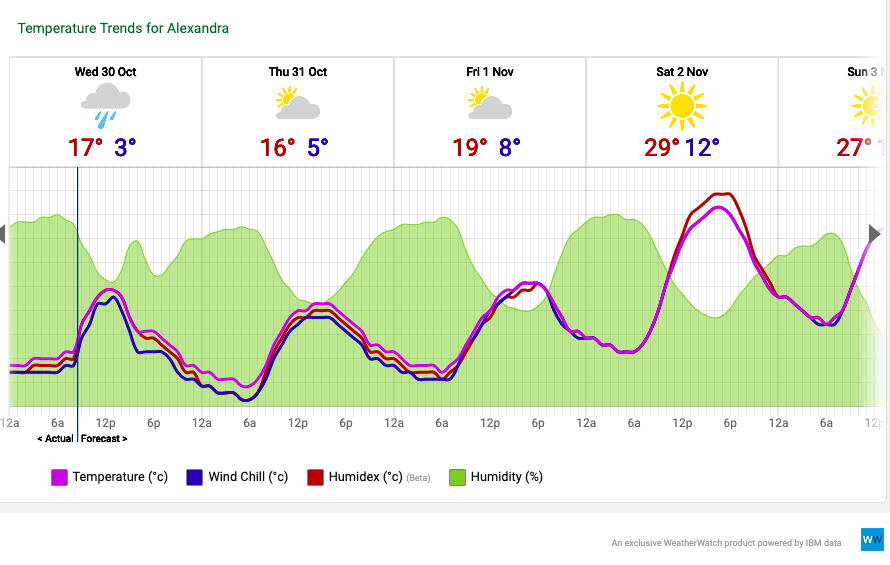
Next week Central Otago is consistently hot with highs in the mid to late 20s and sunny skies – this is a seriously big shift in the pattern of late which has seen low level snow off and on and single digit highs in the area. In fact in the days ahead Alexandra has temperature swings of almost 30 degrees with overnight lows down to around 3 degrees tonight but up around 30 degrees this weekend.
This weekend looks hotter than normal in every part of New Zealand – and drier than average too.
But not every region will be “hot”. Our largest city Auckland has some great weather this weekend – but highs range from 18 to 24 degrees across the region. New Plymouth is similar.
Wellington also has a fairly average weekend although does tip warmer than average on Sunday but Saturday may only make it to 17 degrees.
Dunedin has highs in the early 20s.
WHAT IS CAUSING THIS HEAT?
The hot weather is being caused by a large high in the Tasman Sea. The anticyclonic flow means sub-tropical air is being pushed down over hot inland parts of Australia then directed our way. New Zealand’s hottest days are when we have a direct air flow from Australia’s interior like we do this weekend. If this set up occurs in mid-summer we could be hitting over 40 degrees, which has happened a few times in NZ’s past and has broken heat records.
What does this mean for where you live? Check out www.RuralWeather.co.nz (it has more free weather data than ANY other site on earth for NZ and more than both Government forecasters combined). www.RuralWeather.co.nz will make sense of what this news story means for you – specifically where you live, play or work. (Please note, for first time users this site may take 10 seconds to load. We’re working on a fix for this soon).
SUNDAY’S TEMPERATURE MAP:
EXAMPLE OF TEMPERATURE TREND (From our new weather data website RuralWeather.co.nz)
WHY IS IT HOT THIS WEEKEND? You can thank both Australia and the sub-tropics…
– WeatherWatch.co.nz with www.RuralWeather.co.nz (please note first time users will take 10 seconds to load)
Comments
Latest Video

NZ: 8 Day outlook as gales & rain ease, high pressure builds
Damaging wind gusts and heavy rain will continue to affect some parts of the North Island and brushing Marlborough today…
Related Articles
NZ: 8 Day outlook as gales & rain ease, high pressure builds
Damaging wind gusts and heavy rain will continue to affect some parts of the North Island and brushing Marlborough today…

Pockets of hit & miss heavy rain, snow moves northwards
Low pressure continues to slowly move across the upper North Island and for some that will bring the sun out,…

Slow go for northern low & southern cold
For the next few days low pressure will crawl over the upper North Island, driving in rain as far south…


LM on 29/10/2019 8:15pm
Wintry? Rather dramatic!
WW Forecast Team on 29/10/2019 9:31pm
So you’re definitely not a farmer then. Farmers are telling us it’s wintry and the worst they’ve had in many many years due to recent snow and single digit highs. Townies tend to have a different view.
– WW