Here comes the Snow, Cold and Rain. We have the latest Maps (x5)
30/05/2019 8:17am

> From the WeatherWatch archives
Melbourne just had its coldest May day in 19 years and this southerly blast is now about to pounce on NZ with heavy snow, rain, thunderstorms, gales and a big temperature drop.
Strong to gale force nor’westers have been blasting Canterbury and the lower North Island while heavy rain continues today on the West Coast with over 250mm forecast along with thunderstorms. It’s warmer than average in most places today due to this set up but the cold change arrives today in the lower South Island, spreads north on Friday and covers the entire country by Saturday morning.
RAIN AND SNOW
Heavy snow is expected to develop today and snow levels lowering as the main cold front starts to move in. Queenstown, Lumsden, Te Anau, Cromwell may all get a dusting of snow on either Friday and/or Saturday but heaviest snow will be above 300 to 400m.
Rain will be heavy today on the West Coast, in fact torrential at times (one step up from heavy). Over 250mm is forecast within 24 hours in some areas and more rain is coming on Friday before it finally clears the South Island’s West Coast…because by Friday the main front will be moving into the North Island.
TRAVEL IMPACT
SOUTH ISLAND:
WeatherWatch.co.nz says heavy snow may impact State Highways and Alpine Passes across the South Island in the next couple of days but one positive is that all ski fields – in both main islands – will get a good dumping of snow.
NORTH ISLAND:
Snow is also forecast for State Highway 1, the Desert Road, this weekend with snow flurries falling in Waiouru at times too. There’s a chance snow will also fall in Ohakune and National Park so motorists driving this long weekend need to take extra care and plan accordingly. Monday looks better for the return home.
TEMPERATURES TUMBLE, THUNDERSTORMS BUBBLE
Thursday marks the end in a long run of days well above normal temperature-wise for New Zealand, according to WeatherWatch.co.nz forecasters. By Friday everyone is either average or below average and by Saturday most regions will be below average for June 1st at the warmest point of the day.
Thunderstorms are also bubbling up in the heavy rain slowly moving up the West Coast today. On Friday some of these isolated thunderstorms move into the western North Island too, as the cold front advances northwards and mixes with the warmer than average airflow that is being pushed away from northern NZ.


LIGHTNING AS OF 8:15am – CLICK FOR LIVE VERSION


TEMPERATURES AT HIGHER ALTITUDE – Shows how far north the cold change is going…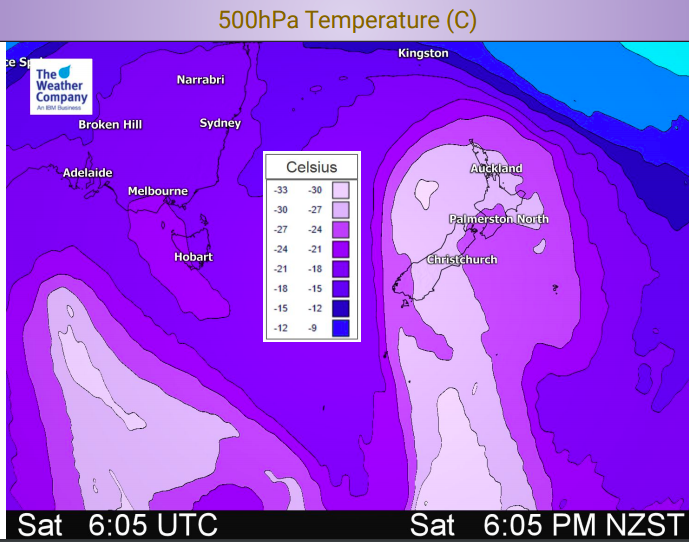
– WeatherWatch.co.nz
Latest Video

Tracking the showers & a potential wintry blast late next week
NZ is on the edge of high pressure with anticyclones moving through at times over the next several days bringing…
Related Articles
Tracking the showers & a potential wintry blast late next week
NZ is on the edge of high pressure with anticyclones moving through at times over the next several days bringing…

Some polar airflows but more high pressure to affect NZ’s weather
Showers are in the forecast over the next several days, we track where and when they occur – but there…

Tracking the showers & colder changes
High pressure isn’t over NZ, but is nearby – and it’s affecting our airflows and who gets wet weather and…

