Your web browser (Internet Explorer) is out of date. Some things will not look right and things might not work properly. Please download an up-to-date and free browser from here.
3:57pm, 2nd July
Home > News > Giant tropical rainmaker set to tease NZ...
Giant tropical rainmaker set to tease NZ for weeks with frustratingly close heavy rain (+Rain Maps)
12/02/2019 4:53am

> From the WeatherWatch archives
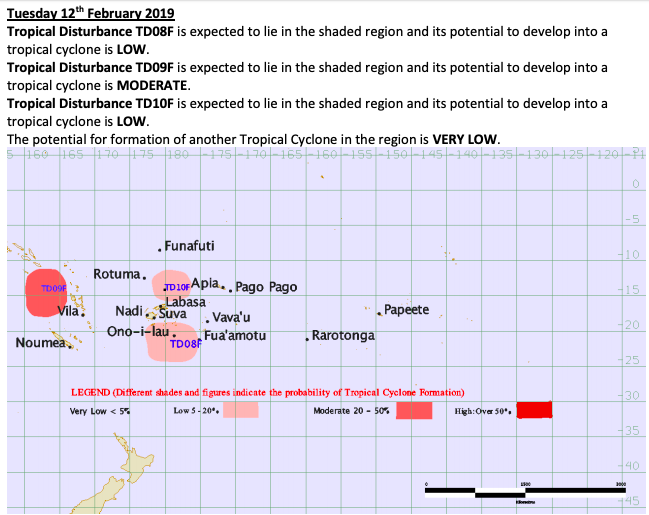
As of Tuesday there are three tropical lows the Fiji Met Service says all have cyclone potential. By Friday or the weekend all will have merged into one super low north of New Zealand with rainfall totals at sea of over 400mm in the two weeks ahead, but here in New Zealand very little wet stuff is forecast.
It’s a forecast that will be incredibly frustrating for many desperately in need of rain with basically two weeks of heavy rain north of the country yet staying close to bone-dry for land here.
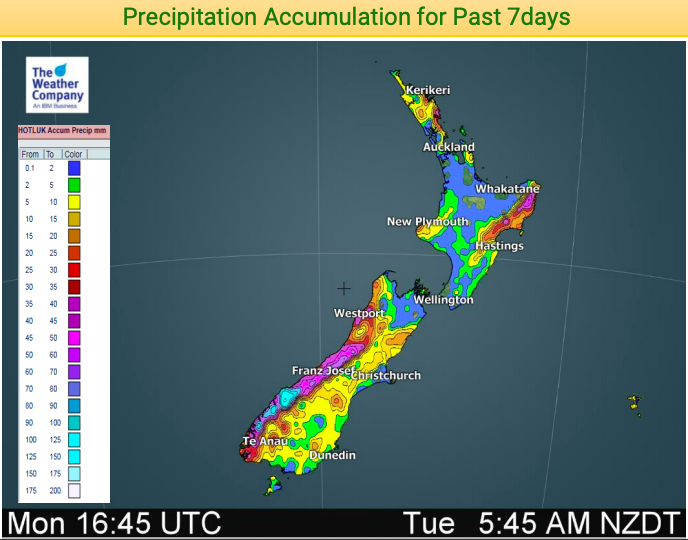
Large parts of New Zealand are now seriously dry with 2019 rainfall so far well below average in a number of regions. The big dry is quickly getting bigger now.
WeatherWatch.co.nz says the driest regions with the most concern are today: The Far North, Northland, Auckland, Waikato, Bay of Plenty, King Country, Taranaki, Whanganui, Manawatu, Horowhenua, Kapiti, Wellington and Nelson.
There are other dry areas too, like Canterbury, Coromandel Peninsula and Wairarapa but the above regions are much drier than normal for this time of the year, soil moisture-wise.
The large tropical low to the north of the country will be frustrating if it doesn’t slide far enough south, with rainfall totals at sea just north east of New Zealand expected to exceed 300 to 400mm over the next two weeks while over land the numbers be just 2 to 20mm. Northland has the best chance of getting rain.
Highs in the New Zealand area will influence the low to the north, possibly even pushing it back north for a time. A lot of moving parts and WeatherWatch.co.nz will do our best to make sense of it all.
WEATHER IN MAPS…
14 Day Rainfall accumulation map shows how much rain is coming just near the upper North Island compared with how little is actually forecast for land. 


ABOVE – TODAY (12th Feb) showing the lows to the north of NZ
BELOW – SUNDAY (24th Feb) 12 days from now still showing a tropical low or storm just north of NZ
FIJI MET SERVICE 3 DAY TROPICAL CYCLONE OUTLOOK:


– WeatherWatch.co.nz
Comments
Before you add a new comment, take note this story was published on 12 Feb 2019.
Latest Video
VIDEO: Severe weather risks for NZ as low moves in
A storm in the Tasman Sea peaks today in power, then drifts towards New Zealand over Thursday to Saturday as…
Related Articles
VIDEO: Severe weather risks for NZ as low moves in
A storm in the Tasman Sea peaks today in power, then drifts towards New Zealand over Thursday to Saturday as…
VIDEO: ClimateWatch: July is the month of BIG lows, BIG highs
This month around New Zealand, Australia and the region we see big highs and big lows – bringing decent stretches…
VIDEO (NZ): Large low looms – who gets rain/wind & who does not
Another large low will bring severe weather to parts of both main islands of NZ this week, followed by a…
Navigation
© 2025 WeatherWatch Services Ltd


Add new comment